Sternstrasse (Trier)
| Sternstrasse | |
|---|---|
| Street in Trier | |
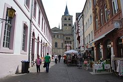
| View through Sternstrasse to Trier Cathedral | |
| Basic data | |
| place | trier |
| District | center |
| Places | Main market , Domfreihof |
The Star Road is a street in the Trier city center . It connects the two central squares Hauptmarkt and Domfreihof . Sternstrasse is one of the city's main shopping streets.
history
The name developed from vicus sub posterna , which means a side entrance that led into the walled cathedral freedom. This was later Germanized as "Unter den Posternen". Later this was shortened to "Unter dem Stern" and finally to today's street names.
Cultural monuments
There are three important cultural monuments in the street . This also includes the building in Stern Straße 6, a four-storey mansard roof residential building with a shop, built according to a design from 1897 for an innkeeper. The late historical building , which towers over the surrounding neighboring buildings, has a clinker brick facade with a lush, neo-baroque sandstone structure. Between the windows of the first floor there are two coat of arms stones from the 16th century from the former gate building of the cathedral immunity: the coat of arms of the cathedral chapter with St. Peter and the coat of arms of Archbishop Richard von Greiffenklau .
The allegedly oldest half-timbered house in Trier, which is dated 1475, is located in Sternstrasse . The building forms the western third of a house that originally extended to the corner of Sternstrasse / Domfreihof and is now later enhanced by three gables. The exposed framework, which was uncovered in 1965, is an important testimony to late Gothic carpentry, both in terms of architecture and construction. Only the two lower floor ceilings of the old interior have been preserved. The vaulted Stadtbach Canal, which was demolished in 1900, has been preserved in the south cellar wall.
In place of Sternstrasse 1, a late historical, but destroyed corner house from 1891 stood until the middle of the 20th century, which was built for the Laeis company according to plans by HO Vogel. The building is a characteristic example of post-war architecture, in which modern new creations are combined with local structural conditions. With its street gable and protruding upper floors, the new building takes up the large form of the late medieval half-timbered house at Sternstrasse 3. The Trier Good Friday procession is shown in 23 scenes in the parapet; this installation was made by the painter Werner Persy , who created it in 1962 using a mixed technique of painting and mosaic. In the gable is Saint Barbara, the patroness of the miners, which refers to the client's coal trade. Except for a later shop extension, which includes the originally open passage along the cathedral courtyard, and the original windows, which have now been expanded, the house has been preserved in its original form.
literature
- Patrick Ostermann (arrangement): Cultural monuments in Rhineland-Palatinate. Monument topography Federal Republic of Germany. Volume 17.1: City of Trier. Old town. Werner, Worms 2001, ISBN 3-88462-171-8
- Ulrike Weber (edit.): Cultural monuments in Rhineland-Palatinate. Monument topography Federal Republic of Germany. Volume 17.2: City of Trier. City expansion and districts. Werner, Worms 2009, ISBN 978-3-88462-275-9 .
- General Directorate for Cultural Heritage Rhineland-Palatinate (publisher): Informational directory of cultural monuments of the district-free city of Trier. (PDF; 1.2 MB) Koblenz 2010.
- Kulturbüro der Stadt Trier (ed.) / Emil Zenz: Street names of the city of Trier: their sense and their meaning. Trier 2003.
Individual evidence
- ↑ Kulturbüro der Stadt Trier (ed.) / Emil Zenz: Street names of the city of Trier: their sense and their meaning. Trier, 2003.
- ↑ a b c Monument topography Federal Republic of Germany. Cultural monuments in Rhineland-Palatinate. Volume 17.1 City of Trier - Old Town. Wernersche Verlagsgesellschaft mbH, Worms. ISBN 3-88462-171-8 (1st edition 2001)
Coordinates: 49 ° 45 ′ 23.9 " N , 6 ° 38 ′ 30.5" E


