Ströms Vattudal
| Ströms Vattudal | ||
|---|---|---|

|
||
| Ströms Vattudal | ||
| Geographical location | Jämtlands län ( Sweden ) | |
| Tributaries | Faxälven | |
| Drain | Faxälven , drain to Fångsjön | |
| Islands | Öhn | |
| Places on the shore | Strömsund | |
| Data | ||
| Coordinates | 63 ° 59 ′ N , 15 ° 24 ′ E | |
|
|
||
| Altitude above sea level | 284 m above sea level | |
| surface | 145.7 km² | |
| length | approx. 70 | |
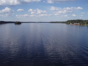
Ströms Vattudal is a lake and an eponymous valley in the north of the Swedish landscape Jämtland . The approximately 70 km long lake extends from Svaningen in the west to a few kilometers east of Strömsund . The lake Ströms Vattudal itself has an area of 145.7 km² and is located at an altitude of 284 m. If you add the Svaningssjön to the west , the area is 166 km². The elongated lake narrows at Strömsund. This divides it into two partial lakes: Gårdsjön in the west and Russfjärden in the southeast. The valley and the lake are traversed by the Faxälven , a tributary of the Ångermanälven . The Russfjärden has several outflows. The main outflow is the Faxälven, which is dammed up downstream and used to generate electricity. Two other outflow arms flow to Fångsjön and on to Sporrsjön . The main outflow of this lake joins the main stream of the Faxälven. However, around 18 percent of the water flows over the Vängelälven to Fjällsjöälven , another tributary of the Ångermanälven.
Individual evidence
- ↑ VISS - Vatteninformationssystem Sverige - Ströms Vattudal
- ↑ Sjöareal och sjöhöjd (3.32 MB; PDF) , Svenskt vattenarkiv (SVAR), Sveriges meteorologiska och hydrologiska institut (Swedish)

