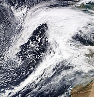
Storm depression Cornelius
| Cornelius / Laura | |
|---|---|
| Storm Cornelius | |
| classification | North Atlantic low |
| storm | hurricane |
| Data | |
| Beginning | 3rd March 2019 |
| Climax | 16./18. February 2020 |
| Top gust | 244 km / h ( Aiguille du Midi , France) |
| consequences | |
The hurricane Cornelius was a hurricane in Northern and Central Europe in March 2019. In Great Britain the storm was named Laura. The storm was part of a major series of storms over Europe in March 2019.
Meteorological process
On March 3, 2019, the deep Cornelius formed over the Atlantic. On the night of March 4, the low with a core pressure of approx. 995 hPa was with its center over the north-western Atlantic. At this point the low was already occluding. In the course of the day, the influence of low pressure at height and on the ground shifts with the base current to the east, so that the Cornelius in the night of March 5 at 1 a.m.CET with a pressure of less than 990 hPa over the eastern North Atlantic off the coasts Europe lay. The fronts separated the maritime polar air flowing in from the north from the more southern maritime subtropical air, which is why the water vapor content in the air condensed due to the large temperature differences and there was increased cloudiness both on and between the fronts. On the Azores, 11 liters of rain fell within 24 hours with a north-westerly approach. The next day the storm shifts to the northeast.
On March 6, 1 a.m. CET, its center was on the ground at almost 980 hPa, intensified over Ireland. The short warm front migrated to France. The longer cold front drew an arc across Spain to the southwest and far across the Atlantic. The now narrow sector between the fronts swept over the British Isles, Spain and France during the day and brought there the influence of warm subtropical air. In the lee of the Pyrenees, maximum temperatures of over 20 ° C were measured, even at night the temperature on the Biscay coast did not fall below 10 ° C. In San Sebastián it even stayed completely above 20 ° C. Germany was also affected by the low on that day, as due to dense clouds in the area of influence, no sunshine could be recorded in the entire north-west of the republic for the entire day. Away from the coast, however, the amounts of precipitation were rather low. A day later, the center of the storm lay over the Scottish capital Edinburgh. With a core pressure of 980 hPa and its center over southern Finland, the storm on March 9th had rotated its fronts cyclonally (counterclockwise) and thereby further occluded. On March 10, the storm eased over the Black Sea
Effects
In the Mont Blanc massif, a gust of 244 km / h occurred in the area of the low. That was the strongest gust since measurements began in 1993. The old record was around, and even in Alpine valleys, gusts due to foehn were still locally hurricane.
Squalls
foreign countries
Source:
| place | country | Strength of the gust in km / h |
|---|---|---|
| Aiguille du Midi |
|
244 |
| Croix de Chamrousse |
|
203 |
| Gütsch ob Andermatt |
|
182.9 |
| place | country | Strength of the gust in km / h |
|---|---|---|
| Altdorf |
|
129.2 |
| Gersau |
|
125.2 |
| Altenrhein |
|
117.3 |
Germany
| place | Strength of the gust in km / h |
|---|---|
| Chunks | 150.80 |
| Zugspitze | 144.40 |
| Kiel | 110.90 |
Source:
Web links
Individual evidence
- ↑ Susanne Haeseler, Peter Bissolli, Christiana Lefebvre, Jan Daßler, Volker Zins: Series of storm lows in March 2019 over Europe with hurricane gusts in Germany. German Weather Service, March 20, 2019, accessed April 4, 2020 .
- ↑ depression CORNELIUS. Retrieved March 15, 2020 .
- ↑ German Weather Service: Sturmsrie 2019. Retrieved on April 3, 2020 .
- ↑ Weather and climate maps. Retrieved April 3, 2020 .
