
Subtropical Storm One (1992)
| Subtropical Storm ( SSHWS ) | ||
|---|---|---|
 |
||
| Emergence | April 21, 1992 | |
| resolution | April 24, 1992 | |
|
Peak wind speed |
|
|
| Lowest air pressure | 1002 mbar ( hPa ; 29.6 inHg ) | |
| dead | 0 | |
| Property damage | 0 US $ (1992) | |
|
Affected areas |
No land areas | |
| Season overview: 1992 Atlantic hurricane season |
||
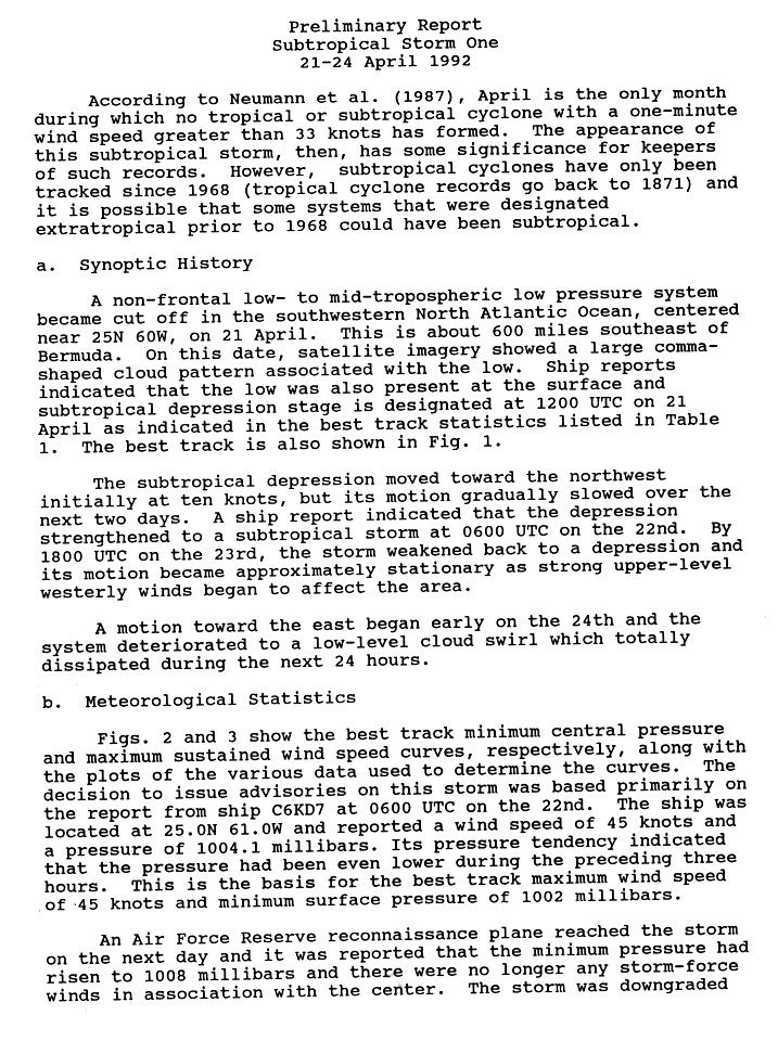
Subtropical Storm One was the first recorded subtropical cyclone of the Atlantic hurricane season in April 1992 . It formed southeast of Bermuda on April 21 and moved northwest, reaching storm strength on April 22. The storm, whose inner core had subtropical properties, reached a peak wind speed of 85 km / h before wind shear weakened the storm. It turned east and disintegrated on April 24th without affecting land.
Storm course

On April 21, a low-pressure area at low and medium altitudes broke away from the west wind zone , about 1,100 km southeast of Bermuda. At the time, the system formed a large cloud pattern resembling a comma , and weather reports from ships indicated that the system was near the surface. Due to the state of organization and the presence of a near-surface circulation, the formation of a subtropical low pressure area was assumed on April 21 at 12:00 UTC ; operationally, however, the system was not classified until 27 hours later. Driven by well-defined control currents, the low pressure area moved northeastward at a forward speed of 10 knots (almost 19 km / h) and intensified into a subtropical storm early on April 22nd.
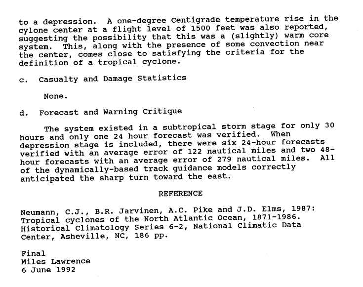
The subtropical storm organized itself continuously better and formed an extensive convection band in its eastern semicircle and after the grading, the storm reached continuous wind speeds of 85 km / h. Strong winds were measured by a ship near the storm center and the National Hurricane Center determined the potential for a transition into a tropical cyclone . Since a ridge formed in the south-east of the storm , the storm moved northwestward and under the influence of an approaching trough the forward speed slowed and the convection decreased. On April 23, the storm became virtually stationary and weakened to a low pressure area after high-altitude wind shear affected the area. A reconnaissance flight inside the system confirmed that wind speeds had decreased. The flight also found that the temperature in the core had increased 1 ° C , indicating the transition to a tropical system, as well as other tropical features.
Early on April 24th, the subtropical low turned eastward. The depth confection in its eastern semicircle was low and the meteorologists at this point assumed that the low would move further east-northeast and become an extra-tropical cyclone. Nevertheless, the resolution was also mentioned as a possibility. Late on April 24th, however, the system was too weak to be classified using the Dvorak technique and the National Hurricane Center issued the final warning that the system did not meet the criteria for a subtropical system either. Within 24 hours, the circulation disappeared and the remaining low moved further east in the westerly wind zone.
Impact, Weather Records, and Naming
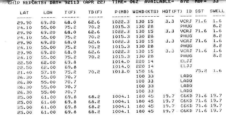
Initially, the subtropical storm appeared to be a threat to Bermuda . The National Hurricane Center saw the probability of the system moving closer than 100 km to the island at 18%; the system remained far southeast of the archipelago. The highest wind speed reported by a ship was the measurement of 85 km / h by Motorschriff using the callsign C6KD7 . The ship reported an air pressure of 1004.1 mbar (hPa) and a swell of 19.7 m; the decision to issue warnings about this system was essentially based on measurements by this ship.
The storm was the first subtropical or tropical cyclone since weather records began to form in the Atlantic Ocean in April. Such storms had previously formed every other month of the year. However, in its preliminary hurricane report, the National Hurricane Center stated, “Sub-tropical cyclones have only been tracked since 1968 (tropical cyclone records go back to 1871) and it is possible that some systems that were classified as extra-tropical before 1968 may have been sub-tropical could be "
Incidentally, the storm was also the first subtropical storm that did not become a tropical system since the 1984 hurricane season . Subtropical cyclones in the Atlantic basin - before 2001 - were not given a name from the list of names of tropical cyclones .
Web links
- National Hurricane Center Preliminary Report for Subtropical Storm One (English)
- 1992 Atlantic Hurricane Season Summary (PDF)
Individual evidence
- ↑ a b c d e f National Hurricane Center: Subtropical Storm One Preliminary Report ( English , GIF) 1992. Retrieved November 7, 2007.
- ↑ a b c Lawrence: Subtropical Storm One Discussion One ( English ) National Hurricane Center. 1992. Retrieved November 7, 2007.
- ^ Jarrell: Subtropical Storm One Discussion Three . National Hurricane Center. 1992. Retrieved November 7, 2007.
- ↑ National Hurricane Center: Subtropical Storm One Preliminary Report (Page 2) ( English , GIF) 1992. Retrieved November 7, 2007.
- ^ Rappaport: Subtropical Depression One Discussion Seven ( English ) National Hurricane Center. 1992. Retrieved November 7, 2007.
- ↑ Lawrence: Subtropical Depression One Discussion Nine , National Hurricane Center. Retrieved November 7, 2007.
- ↑ Lawrence: Subtropical Storm One Strike Probabilities ( English ) National Hurricane Center. 1992. Retrieved November 7, 2007.
- ^ National Hurricane Center: April 22, Ship Data ( English , GIF) 1992. Retrieved November 7, 2007.
- ^ National Hurricane Center: Subtropical Storm One Preliminary Report ( English , GIF) 1992. Retrieved November 7, 2007: “ subtropical cyclones have only been tracked since 1968 (tropical cyclone records go back to 1871) and it is possible some systems that were designated extratropical prior to 1968 could have been subtropical. "