
Swartberg
| Swartberg | ||
|---|---|---|
| Highest peak | Seweweekspoortpiek ( 2325 m ) | |
| location | Western Cape Province ( South Africa ) | |
|
||
| Coordinates | 33 ° 22 ′ S , 22 ° 21 ′ E | |

The Swartberge ( Afrikaans : Groot Swartberge ) are a mountain range in the Western Cape Province , South Africa . They belong to the cape pleated belt . The highest mountain is the Seweweekspoortpiek at 2325 meters above sea level. Although the Swartberg Mountains consist mainly of red rock, the name translates as "black mountains". Erosion and vegetation have colored the surface dark, and from a great distance the mountains looked black to the first settlers.
The mountain range separates the Great Karoo from the Little Karoo . At the foot of the mountains are the places Oudtshoorn in the south, Prince Albert in the north and de Rust in the east. The main road through the Swartberge is the N12 , which runs through the Meiringspoort gorge. It is well developed and leads relatively flat along the river from Prince Albert to de Rust. About 29 km north of Oudtshoorn are the Cango Caves .
However, the Swartberg Pass is a special tourist attraction . It was built between 1881 and 1886 by Thomas Bain , the most important road builder of the 19th century in South Africa. The 27-kilometer-long unpaved pass road reaches a height of 1583 meters. On the 100th anniversary of the opening, the Swartberg Pass was declared a national monument of South Africa.
The Swartberg Mountains are one of the eight protected areas in the Cape Floral region and have been a UNESCO World Heritage Site since 2004 .

The Swartberg Mountains on the horizon

Pass road on Swartberg

View from the pass

Folded rock
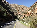
The N12 in the Meiringspoort gorge


Web links
- Side of the park management Cape Nature (English)
- Entry in the UNESCO World Heritage List (English) (French)

