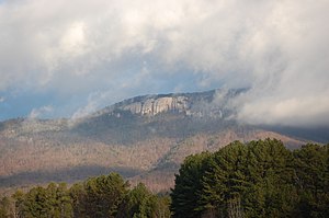
Table Rock State Park, South Carolina
|
Table Rock State Park
|
||
| location | Pickens County in South Carolina (USA) | |
| surface | 12.48 km² | |
| Geographical location | 35 ° 2 ' N , 82 ° 42' W | |
|
|
||
| Setup date | 1935 | |
| administration | South Carolina Department of Parks, Recreation & Tourism | |
The Table Rock State Park is a 12.48 km² large park on the edge of the Blue Ridge Mountains in Pickens County , South Carolina , United States. Pinnacle Mountain is the highest mountain in the state park and also South Carolina.
In the park is a hostel built by the Civilian Conservation Corps (CCC). The approximately 3.2 km long Carrick Creek nature trail (circular route) leads around two streams with small waterfalls and shows the native flora. An approximately 5.8 km long hiking trail leads over the Governor's Rock (870 meters above sea level) to the 952 meter high Table Mountain that gives it its name. The actual lookout point is a few hundred meters behind the summit.
The neighboring 1,043 m high Pinnacle Mountain is also accessible via a 6.8 km long hiking trail, but due to its wooded summit there is no view. However, the ascent offers numerous viewpoints, is very varied and, especially on weekends, not as busy as the heavily frequented Table Mountain.
The park has been listed as a Table Rock State Park Historic District on the United States' National Register of Historic Places since June 15, 1989 .
supporting documents
- ↑ Hiking Trails at Table Rock State Park. Retrieved October 31, 2015 .
- ↑ Reference 89000478, NRIs database of the National Park Service


