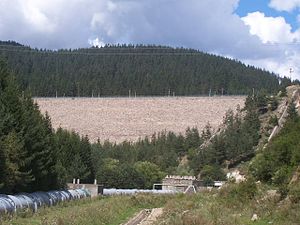
Dospat dam
| Dospat dam | |||||
|---|---|---|---|---|---|
|
|||||
|
|
|||||
| Coordinates | 41 ° 38 ′ 34 " N , 24 ° 9 ′ 12" E | ||||
| Data on the structure | |||||
| Height above foundation level : | 60.5 m | ||||
| Height of the structure crown: | 1200.5 m | ||||
| Crown length: | 230 m | ||||
| Data on the reservoir | |||||
| Altitude (at congestion destination ) | 1197.13 m | ||||
| Water surface | 22 km² | ||||
| Storage space | 447.13 m³ | ||||
| Total storage space : | 449.22 million m³ | ||||
The Dospat Dam is located in Smolyan Oblast , Bulgaria . It dams the Dospat , a left tributary of the Nestos , to a reservoir. The dam was completed in 1969. The village of Dospat is in the immediate vicinity of the dam.
Barrier structure
The barrier structure is a stone embankment dam with a height of 60.5 m above the foundation level . The length of the dam crest is 230 m. The top of the dam is at a height of 1200.5 m above sea level . The dam has a clay core for sealing.
The dam has a flood relief system , through which a maximum of 36 m³ / s can be discharged.
Reservoir
With the normal storage target of 1197.13 m (max. 1197.75 m at high water), the reservoir extends over an area of around 22 km² and holds 449.22 million m³ of water - 447.13 million m³ of this can be used to generate electricity become. The minimum congestion target up to which electricity generation is still possible is 1174 m.
Teschel power plant
A pressure pipeline leads from the Dospat reservoir , which supplies the Teschel hydropower plant, which is about 15 km away, with the necessary water.
See also
Web links
Individual evidence
- ↑ a b c Hydro Power Cascades and Dams. (PDF) Nazionalna Elektritscheska Kompanija EAD (NEK EAD), pp. 21–23 (23–25) , accessed on August 10, 2018 (English).

