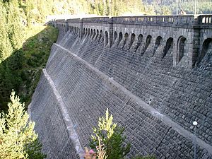
Golyam Beglik dam
| Golyam Beglik dam | |||||
|---|---|---|---|---|---|
|
|||||
|
|
|||||
| Coordinates | 41 ° 48 '57 " N , 24 ° 7' 47" E | ||||
| Data on the structure | |||||
| Height above foundation level : | 46.5 m | ||||
| Height of the structure crown: | 1528.5 m | ||||
| Crown length: | 191 m | ||||
| Data on the reservoir | |||||
| Altitude (at congestion destination ) | 1527.3 m | ||||
| Water surface | 4.126 km² | ||||
| Storage space | 58.17 | ||||
| Total storage space : | 62.11 million m³ | ||||
The Golyam Beglik Dam is located in the Pazardzhik Oblast , Bulgaria . It dams the Kriwa to a reservoir. The dam was completed in 1951.
Barrier structure
The barrier structure is a gravity dam made of masonry with a height of 46.5 m above the foundation base . The length of the top of the wall is 191 m. The top of the wall is at a height of 1528.5 m above sea level .
The dam wall has both a bottom outlet and a flood relief . A maximum of 36 m³ / s can be discharged via the bottom outlet, and a maximum of 50 m³ / s via the flood discharge.
Reservoir
With the normal storage target of 1527.3 m (max. 1528.2 m at high water), the reservoir extends over an area of around 4.126 km² and holds 62.11 million m³ of water - 58.17 million m³ of this can be used to generate electricity become. The minimum congestion destination up to which electricity can still be generated is 1503 m.
Batak power plant
A tunnel leads from the Goljam Beglik reservoir through which the Batak hydropower plant, which is about 13 km away, is supplied with the necessary water.
See also
Individual evidence
- ↑ a b c Hydro Power Cascades and Dams. (PDF) Nazionalna Elektritscheska Kompanija EAD (NEK EAD), pp. 15–17 (17–19) , accessed on August 8, 2018 (English).

