Tapon del Darién

The last gap in the Panamericana , a continuous road connection between Alaska in North America and Tierra del Fuego in South America , is called Tapón del Darién ( "Darién obstacle" , also known under the English name Darién Gap ) .
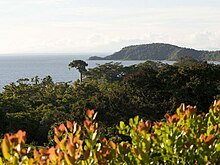
The location is in Darién , a rainforest area in southeast Panama and northwest Colombia . There are no roads in this mountainous and swampy area. To connect North and South America, around 110 km of road would be required. Seen from the north, the southernmost vehicle-accessible point is Yaviza in Panama. The northern endpoints seen from South America are Barranquillita and the port city of Turbo in Colombia.
Reasons for the loophole
There are various reasons why the route has not yet been completed.
On the one hand, the construction in this area requires a relatively high financial outlay, as the terrain is mountainous and is also criss-crossed by numerous watercourses and swamps, which would require the construction of many bridges. However, this is not the only reason, as the governments of Panama and Colombia have announced several times that they want to start construction. More serious are the arguments on the basis of which a road link in this area is considered harmful to the environment. Conservationists are demanding that the area covered by rainforest continue to be preserved as wilderness. In their opinion, a road link would lead to an economic development of the area, an increase in population density and, as a result, a gradual deforestation of the rainforest. In addition, it is feared that the foot-and-mouth disease, which has been eradicated there for decades, will be reintroduced to North and Central America if uncontrolled livestock transports become possible through a road link.
Most of the residents of the area, mostly Chocó and Kuna Indians, are against building a road. They argue that the street could endanger their traditional way of life and amount to "cultural colonization" of the area.
Another obstacle is that some guerrilla groups ( ELN and FARC ) are active in the Colombian part of the area . This situation has worsened rather than eased, especially since 1997, but there has been a peace treaty since 2016 , which enables the crossing to be somewhat less dangerous.
accessibility

Although there is no road connection in the area, there is an extensive network of paths and trails. It is therefore possible, for example, to cross the gap on foot, since boats are usually available for rent on every river near settlements. The rivers can also be crossed by swimming. The Tapón del Darién has also been conquered with motorbikes and four-wheel drive vehicles, for the first time in 1960. Likewise, the Tapón del Darién has already been crossed with bicycles , whereby the bicycles had to be carried over long distances. In practice, however, this type of crossing of the area is not recommended today because of the guerrilla activities.
tourism
Since the 1980s, the Tapón del Darién has become a sought-after destination for adventure tourists. Its “conquest” is still considered a challenge. However, after the guerrilla movement flared up again in 1997, tourism came to an almost complete standstill.
Drug trafficking
The lack of a land connection between North America and South America made the Gulf of Urabá a hotspot for drug trafficking . Airplanes, speedboats and submarines are used to transport the goods.
Road construction activities
In 2010, Colombia announced the Transversal de las Américas road construction project, which, among other improvements to the northern Colombian road network, also provides for the construction of a road through the Darién to the border with Panama at Palos de Las Letras . This would mean that the missing gap in the Panamericana would only be about 50 km long. However , in response to the announcement, the Panamanian government under Ricardo Martinelli rejected the connection from Yaviza to this border post through its own construction activities.
Individual evidence
- ^ Georg Ismar and Rodrigo Ruiz-Tovar: German U-Boats in the Anti-Drug Fight. In: Saxon newspaper. December 8, 2015, accessed December 8, 2015 .
- ^ Colombia: New major infrastructure project Transversal de las Américas ; Quetzal Magazine, August 5, 2010
- ↑ José Arcia: Los últimos 80 kilometers de una polémica carretera prensa.com, from August 8, 2010 (Spanish)
Coordinates: 8 ° 9 ′ 0 ″ N , 77 ° 40 ′ 59 ″ W.
