Tapsa
| Tapsa | |||
|---|---|---|---|
| Korean alphabet : | 탑사 | ||
| Chinese characters : | 馬 耳 山 塔寺 | ||
| Revised Romanization : | Tapsa | ||
| McCune-Reischauer : | Tapsa | ||
| Basic data | |||
| Province : | Jeollabuk-do | ||
| Coordinates : | 35 ° 45 ′ N , 127 ° 25 ′ E | ||
| map | |||
|
|||
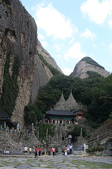
The Tapsa Temple ( kor. 탑사 ) is a pagoda temple and is located at the foot of the Maisan in the Maisan Provincial Park, Jinan County, Jeollabuk-do Province .
The hermit Yi Gap-yong (1860–1957) came to Maisan when he was 25 years old to practice meditation. Over the next few decades, he built around 120 stone pagodas without mortar or similar fasteners. He erected the stone structures, some of which are 10 meters high, without any technical aids. The pagodas defy all wind and weather to this day.
Web links
Commons : Tapsa - collection of images, videos and audio files
- Website of attractions in Jinan (English)
- Temple website (Korean)

