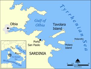
Tavolara Archipelago
| Tavolara Archipelago | ||
|---|---|---|
| Waters | Tyrrhenian Sea | |
| Geographical location | 40 ° 53 ' N , 9 ° 42' E | |
|
|
||
| Number of islands | 2 main islands | |
| Main island | Tavolara | |
| Residents | 20th | |
The Tavolara Archipelago or the Tavolara Archipelago is a group of two larger and some small islands and rocks off the north east coast of Sardinia , south of La Maddalena between Capo Ceraso north and Punta Coda Cavallo south. It is named after the largest island, Tavolara , which is also the only one inhabited.
The entire area has been designated as a marine reserve Tavolara Punta Coda Cavallo since 1997 . The eastern south coast of Tavolara and the small rocky island of Molarotto with the surrounding sea are completely protected, which means that staying there is completely forbidden. Both on the islands and in the surrounding sea, there is a rich fauna of rare or endangered species, Shag , Audouin and the Mediterranean shearwater , a blue colored subspecies of the Tyrrhenian wall lizard , on Molarotto endemic is, and marine mammals such as Risso's dolphin and sperm whale , as large representative of the cartilaginous fish also the basking shark .
| Surname | Remarks | surface | location | image |
|---|---|---|---|---|
| Barca Sconcia | 40 ° 55 ′ 3 " N , 9 ° 38 ′ 50" E | |||
| Tavolara | 4.7 km² | 40 ° 54'26 " N , 9 ° 42'56" E | ||
| Isolotto dei Topi / Isola Verde | 40 ° 53 ′ 48 " N , 9 ° 40 ′ 30" E | |||
| Spalmatore / Isola dei Porri | 40 ° 53 ′ 38 " N , 9 ° 40 ′ 5" E | |||
| Isola del Fico | 40 ° 52 ′ 31 " N , 9 ° 42 ′ 28" E | |||
| Isola Piana di Tavolara | 0.13 km² | 40 ° 53 ′ 18 ″ N , 9 ° 39 ′ 6 ″ E | ||
| Isola dei Garofani | 40 ° 53 ′ 10 " N , 9 ° 38 ′ 0" E | |||
| Isola dei Cavalli | 40 ° 53 ′ 8 " N , 9 ° 38 ′ 25" E | |||
| Reulino / Isolotto Rosso | 40 ° 52 ′ 40 " N , 9 ° 40 ′ 17" E |
|
||
| Molarotto | 40 ° 52 ′ 28 " N , 9 ° 46 ′ 41" E | |||
| Molara | 3.48 km² | 40 ° 52 '8 " N , 9 ° 43' 40" E | ||
| Cana | 40 ° 51 ′ 52 " N , 9 ° 40 ′ 37" E | |||
| I tre fratelli / I Cerri | three small rocks | 40 ° 51 ′ 43 " N , 9 ° 45 ′ 42" E | ||
| L'Isoledda | 40 ° 51 ′ 1.5 ″ N , 9 ° 41 ′ 29 ″ E | |||
| Proratora | 40 ° 50 ′ 47 " N , 9 ° 43 ′ 23" E |
Web links
Individual evidence
- ^ Charles Arnold (ed.): The islands of the Mediterranean . A unique and complete overview. 1st edition. marebuchverlag, Hamburg 2008, ISBN 3-86648-096-2 .


