Tavolara
| Tavolara | ||
|---|---|---|
| View from the coast of Sardinia to Tavolara | ||
| Waters |
Gulf of Olbia ( Tyrrhenian Sea ) |
|
| Archipelago | Tavolara Archipelago | |
| Geographical location | 40 ° 54 '26 " N , 9 ° 42' 43" E | |
|
|
||
| length | 6 km | |
| width | 1 km | |
| surface | 6 km² | |
| Highest elevation | Punta Cannone 564 m |
|
| Residents | 20th 3.3 inhabitants / km² |
|
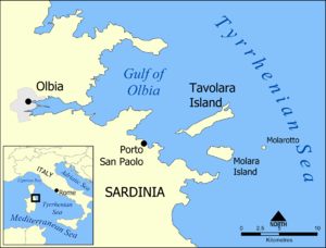
| Location of the island in the Gulf of Olbia | ||
Tavolara is one of the Northeast coast of Sardinia offshore island with steep cliffs and the flat promontory Spalmatore di Terra in the West. It is about six kilometers long and one kilometer wide.
history
The first inhabitants on the island about five kilometers off the coast were Stone Age fishermen around 4000 BC. Chr.
At the beginning of the 19th century the Corsican Giuseppe Bertoleoni came to Sardinia with his family and settled on the uninhabited island of Tavolara. When King Carlo Alberto of Sardinia went ashore on the Tavolara in 1836 , Giuseppe's son Paolo met him and announced: "The King of Tavolara welcomes the King of Sardinia and wishes him a pleasant stay in his kingdom."
Carlo Alberto found the joke amusing and gave him the island as a present. Bertoleoni had this donation confirmed in writing. The smallest kingdom in Europe was born. The descendants named themselves Karl I, Paul I etc. 1962 the independence of the island ended. Today the descendants of "King Paolo" work as innkeepers and skippers.
On the island of Tavolara there has been a military restricted area of NATO which covers half the island since 1962 , on which a telecommunications and interception center with long-wave transmitter is operated.
Today 15 to 20 people live on the island, all of them belonging to the Bertoleoni family. The small island cemetery, where the graves of the kings and their families can be found, is located roughly in the middle of the flat headland.
geology
The island of Tavolara consists of white dolomite limestone from the Mesozoic Era on a granite base and the highest point on the island is Punta Cannone at 564 meters.
geography
The marine park Tavolara Capo Coda Cavallo is located near Olbia in the province of Gallura and consists of three islands:
natural reserve
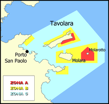
This area with an area of 15,000 hectares was placed under nature protection in 1997 and divided into protection zones A, B and C:
- Zone A - swimming prohibited; Enter only for scientific activities
- Zone B - diving and fishing is only permitted to a limited extent
- Zone C - protected area
The island of Tavolara is about four kilometers off the coast. A ship transfer is operated from Porto San Paolo . In front of the island is the diving area Secca del Papa (Shoal of the Pope).
fauna
The now extinct Sardinian pika lived in Corsica and Sardinia - it was probably last observed on Tavolara in 1774. There are also wild goats, eagles and peregrine falcons on the island.
Web links
Individual evidence
- ↑ Stefan Ulrich: Arrivederci, Roma! Ullstein, Berlin 2010 ISBN 978-3-548-28143-8 , p. 31f.
- ^ A b Adele Evans, Peter Höh: Baedeker SMART travel guide Sardinia. Perfect days on the island with the dream beaches. Mair Dumont, 2015 ISBN 978-3-8297-8142-8 , p. 133.
- ↑ La fiaba dell'isola di Tavolara: Il regno più piccolo del mondo
- ^ Prolagus sardus on the IUCN Red List of Threatened Species .


