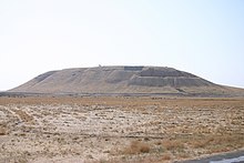
Tell Barri
Coordinates: 36 ° 44 ′ 21 ″ N , 41 ° 7 ′ 28 ″ E
Tell Barri is a tell in the al-Hasakah governorate in northeast Syria and is located there on the Naḫr Jaqjaq , a tributary of the Chabur . He is identified with the ancient city of Kaḫat ; an assignment that has been considered secured since a corresponding inscription was found on a lintel. The mighty Tell Brak is located in the immediate vicinity of Tell Barri . The Tell rises around 30 m above the surrounding plain and has a surface of around 37 hectares. Archaeological excavations took place there in the 1960s and again since 2006.
Tell Barri had been settled since the Halaf period . However, the place did not move into the light of history until the early 2nd millennium BC. BC, from which historical sources on Kaḫat come for the first time in the Mari archives . Accordingly, it was ruled by vassals of mario-Nazi ruler until it into the sphere of influence of obermesopotamischen kingdom of Samsi-Adad I became. The capital of this empire was Subat-Enlil , identified with Tall Leilan, northeast of Tell Barri . From there, the king's harem fled to Kaḫat when the Upper Mesopotamian Empire collapsed.
However, Tell Barri experienced its heyday from the 2nd half of the 2nd millennium BC. As part of the Mitanni empire , it was an important place of worship where the weather god Teššup was worshiped. After it was conquered by the Assyrians, Tukulti-Ninurta II built a palace there. The place survived the fall of the Assyrian Empire and was further populated in the following epochs up to the Arab Middle Ages.
literature
- Paolo Emilio Pecorella: Tell Barri / Kahat: La campagna del 2000 . Firenze University Press, Florence 2003, ISBN 88-8453-097-0 .
- Paolo Emilio Pecorella and Raffaella Pierobon Benoit: Tell Barri / Kahat: La campagna del 2001 . Firenze University Press, Florence 2004, ISBN 88-8453-140-3 .
- Paolo Emilio Pecorella and Raffaella Pierobon Benoit: Tell Barri / Kahat: La campagna del 2002 . Firenze University Press, Florence 2005, ISBN 88-8453-291-4 .
Web links
- http://www.tellbarri.com/ (English)

