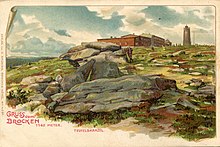
Teufelskanzel (Brocken)
The Teufelskanzel is a rock formation in the Harz Mountains in Saxony-Anhalt .
geography
The Teufelskanzel belongs to the Harz cliffs and is located on the top of the Brocken . Politically, this rock formation is located in the municipality of the city of Wernigerode in the Harz district in Saxony-Anhalt .
The devil's pulpit is made of granite. It is located directly in the strictly protected core zone of the Harz National Park and is therefore no longer accessible to the public as it is not accessible by paths. But it can be clearly seen in the landscape from the Brockenkuppe.
Immediately next to the devil's pulpit is the witch's altar , a similar rock formation around which there are also several Brock sagas . There was also the witch's washbasin, which was located near the Brocken clock .
history
The names of the devil's pulpit and witch's altar are more recent and can be found in the late 17th century with increasing tourism on the Brocken. Both are associated with the legends of the Walpurgis Night from April 30th to May 1st.
Due to its peculiar appearance and its location on the footpath on the Brocken, the Teufelskanzel was once an extremely popular destination for many Brocken hikers who climbed the rock formation. It was often used as a postcard and photo motif.
Around the Teufelskanzel is u. a. the legend of the devil preaching to the guests of the Brockens there. In the 18th century it was still believed that an idol was once erected on the Devil's Pulpit.
Goethe's companion Georg Melchior Kraus also drew the devil's pulpit and witch's altar during the Brocken visit, and Goethe expressly noted in his review of the Brocken's visit in the winter of 1777, written on September 9, 1830 in Weimar, that it was standing next to the devil's pulpit.
literature
- Walther Grosse : History of the city and county of Wernigerode in their forest, field and street names (= research and sources on the history of the Harz region, volume 5), Wernigerode 1929, p. 76.
Individual evidence
- ↑ Federal Agency for Cartography and Geodesy, State Enterprise Geobasis Information and Surveying Saxony (GeoSN): Digital Topographic Map 1:50 000.
- ↑ Walther Grosse : History of the city and county of Wernigerode in their forest, field and street names , Wernigerode [1929]
- ↑ Heinrich Pröhle : Unterharzische Sagen, Aschersleben , 1856.
- ^ Braunschweigische advertisements , Volume 24, 1784, column 603.
- ↑ Johann Wolfgang von Goethe: Complete Works , Volume 43, Weimar 1830, p. 57.
Coordinates: 51 ° 47 ′ 51.7 ″ N , 10 ° 36 ′ 58.5 ″ E

