Thompson Island (South Atlantic)
Coordinates: 53 ° 56 ′ S , 5 ° 30 ′ E

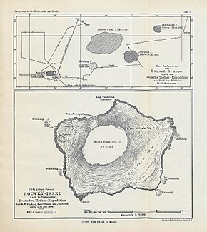
The Thompson Island ( English Thompson Island ) is a so-called phantom island in the southern Atlantic Ocean . You should be the north-east about 150 km Norway belonging Bouvet Island have found.
prehistory
On October 6, 1808, Captain James Lindsay of the Swan sighted Bouvet Island at 54 ° 22 ′ S; 4 ° 15 ′ E again. Since he was not aware of the first discovery of Bouvet de Lozier in 1739, he considered his island sighting, which was later called 'Lindsay Island', to be a new discovery. The next sighting of Bouvet Island was made by Captain George Norris of the Sprightly on December 10, 1825. He named the - actually existing - island Liverpool Island , landed there on December 16 and formally took possession of it in the name of the British King George IV .
Thompson Island
Between December 13 and 16, 1825, Norris drove the area in the northeast of the Lindsay or. Liverpool Island and discovered a supposed second island. It was small and low with huge surf. Three miles south-east of this second island he found three rocky islets, and three miles further south of them a lonely rock. Norris named the island in the northeast of Lindsay / Liverpool Island Thompson Island and the three rocky islets after their shape Chimneys (Eng. "The chimneys"). Norris wrote the positions of these new discoveries on a map. Unfortunately, the position of Thompson Island on this map does not match Norris' log. In 1853, Lindsay Island , Bouvet or Liverpool Island , Thompson Island and The Chimneys appeared on a British Admiralty nautical chart. In 1893 the American captain Joseph J. Fuller (1839-1920) claims to have sighted Thompson Island again on the Francis Allyn .
When the German Valdivia expedition wanted to determine the exact position of the island in November 1898, however, it could not be found. As part of the Norwegian Antarctic Expedition (1928 to 1929), Ola Olstad and Nils Larsen finally declared Thompson Island to be "nonexistent".
According to Hubert Lamb , the island could possibly have sunk as a result of a volcanic eruption between 1893 and 1898. At the position given by Norris, however, the sea is 2,400 m deep.
The Thompson Island was only sighted by Norris. Fuller's alleged second sighting in 1893 - he describes Bouvet Island almost word for word in Norris' diary - must therefore be seriously questioned.
Today it can be seen as certain that Thompson Island, the Chimneys and the isolated individual rock were drifting icebergs that were dark in color due to rock inclusions. The idea of a multi-part archipelago could arise because the sea area in question was still absolutely unknown around 1825 and therefore length displacements, i.e. incorrect positions of Bouvet Island due to inadequate methods of determining length, were held for other islands.
See also
Web links
- A Bibliography of Antarctic Fiction (English)
literature
- Gerhard Engelmann: The Bouvet Island. With 4 cards. In: Geographical Journal . Volume 46, No. 11, Leipzig 1940, pp. 408-424.
- Rupert Thomas Gould: Oddities: a book of unexplained facts . London 1928 (Chapter VII: The Auroras, and other doubtful islands pp. 190–247)
Individual evidence
- ↑ Hubert H. Lamb: The Problem of Thompson Island ( Memento July 7, 2015 in the Internet Archive ) . In: British Antarct. Surv. Bull. 13, 1967, pp. 85-88 (English; PDF; 1.3 MB)
- ↑ volcanodiscovery.com: Thompson island
