Torlesse Islands
| Torlesse Islands | ||
|---|---|---|
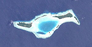
| NASA satellite image of the Torlesse Islands | ||
| Waters | Solomon Lake | |
| archipelago | Louisiade Archipelago | |
| Geographical location | 10 ° 49 ′ S , 152 ° 11 ′ E | |
|
|
||
| Number of islands | 7th | |
| Main island | Pananiu | |
| Total land area | 2.08 km² | |
| Residents | uninhabited | |
The Torlesse Islands are an uninhabited group of islands in the Solomon Sea . Politically, they belong to the Milne Bay province in the southeastern area of Papua New Guinea . They are located 13 km from Misima and 5 km west of the Deboyne Islands . The aggregate land area of the seven islands is 2.08 km².
Table of the islands
Overview of the Torlesse Islands: Map with all coordinates: OSM | WikiMap
![]()
| Island name | Coordinates | Area km² |
|---|---|---|
| Pananiu | 10 ° 49 ′ S , 152 ° 11 ′ E | 0.86 |
| Bonna Bonnawan | 10 ° 48 ′ S , 152 ° 12 ′ E | 0.18 |
| southernmost island (unnamed) | 10 ° 49 ′ S , 152 ° 13 ′ E | 0.03 |
| Island (unnamed) | 10 ° 49 ′ S , 152 ° 13 ′ E | 0.01 |
| Tinolan | 10 ° 48 ′ S , 152 ° 13 ′ E | 0.80 |
| Island (unnamed) | 10 ° 49 ′ S , 152 ° 13 ′ E | 0.05 |
| Rerihol | 10 ° 49 ′ S , 152 ° 14 ′ E | 0.15 |
Web links
- Torlesse Atoll, Papua New Guinea on Panoramio
- Deboyne Islands with Torlesse Islands, Oceandots.com (further information & pictures) ( Memento from December 23, 2010 in the Internet Archive ) (engl.)

