Troll (research station)
Coordinates: 72 ° 0 ′ 44.1 ″ S , 2 ° 32 ′ 2.8 ″ E
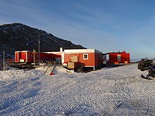
The Troll Research Station ( Norwegian Troll forskingsstasjon ) is an Antarctic research station of the Norwegian Polar Institute in the eastern part of the Princess Martha Coast in Queen Maud Land . It was built during the Norwegian expedition 1989–1990 . It stands 235 kilometers from the coast on the rocky bottom of the Nunatak Jutulsessen at 1,270 meters above sea level.
The station was manned only during the Antarctic summer until February 2005 when permanent residence facilities were built. While there is space for eight people in winter, up to forty people can stay in summer thanks to a tent camp.
On February 12, 2005, the station was officially opened by Her Majesty Queen Sonja of Norway for year-round manned operations.
At the troll station, meteorological and UV measurements are carried out and glaciological, biological and physical examinations are carried out.
2005 km north-northwest of the station 6.8 on the ice the runway Troll Airfield built. In December 2012, the first test flights with a Boeing 737 were undertaken, which should provide information about a future replacement of the Hercules C-130 previously used .
In 2016, a photovoltaic system with a peak output of 7.3 kilowatts was installed. If this proves itself in the extreme weather conditions, it should be expanded in order to reduce the dependence on oil.
Individual evidence
- ^ NRK: Landet med 737 i Antarktis (Norwegian), accessed on December 5, 2012.
- ↑ pv magazine: Antarctica: Solar system reduces diesel consumption in research station (German), accessed on March 10, 2016.

