
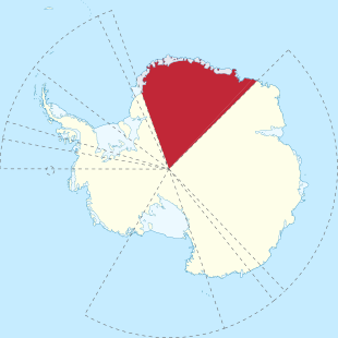
Queen Maud Land
| Dronning Maud Land | |||||
| Queen Maud Land | |||||
|
|||||
| Official language | Norwegian | ||||
| Form of government | Secondary area (claim not recognized internationally) | ||||
| Head of state , also head of government | King Harald V. | ||||
| surface | 2,741,000 km² | ||||
| currency | Norwegian krone | ||||
| Time zone | UTC + 2 | ||||
| Internet TLD | .no, .aq | ||||
  |
|||||


Queen Maud Land (Norwegian: Dronning Maud Land ) is part of the continent of Antarctica . It has been claimed by Norway since January 14, 1939 , but this is not recognized internationally. The area has a size of about 2,700,000 km². It was named after Queen Maud (1869–1938).
history
The coastal strips known as the Crown Prince Olav Coast and Princess Ragnhild Coast were discovered in 1929/30 by the Norwegian aviation pioneers Hjalmar Riiser-Larsen and Finn Lützow-Holm .
The Norwegian ship owner and whaling magnate Lars Christensen paved the way for Norway to claim the region by financing nine expeditions (1927–1937) to the region. The main objective was to explore new whaling grounds after the British government imposed license fees for whaling off the coasts of the British Antarctic Territory .
In 1938 the German Reich sent the German Antarctic Expedition on the German expedition ship Schwabenland . The aim of the expedition was to secure whaling rights off the coast of the expedition area. As part of the scientific part of this expedition, the ice-free mountains in the hinterland of the coast were photographed for the first time in January 1939 from Dornier aircraft . The viewed and overflown region between 10 ° W and 15 ° E was christened “ Neuschwabenland ” by the expedition leader and claimed by the German Empire, which, like the claim of the Norwegians as Queen Maud Land, is not recognized internationally.
The first scientific expedition into the interior of Queen Maud Land was the Norwegian-British-Swedish Antarctic Expedition from 1949 to 1952.
The southern boundary was not established in 1939, it was not until June 12, 2015 that Norway formally claimed the sector up to the South Pole.
geography
Enderbyland, part of the Australian Antarctic Territory , joins in the east , and the Coatsland, part of the British Antarctic Territory, and the Caird coast in the west .
From the coast or the edge of the ice shelf , the glaciers gradually rise to over 1000 m. This is followed by the region of the nunataks rising from the ice and mountain ranges with altitudes sometimes over 3000 m. From west to east the Kraulberge , Heimefrontfjella , Borg-Massif , Gjelsvikfjella , Mühlig-Hofmann-Gebirge , Wohlthatmassiv , Sør Rondane and Belgicafjella are the most important mountains. These mountain ranges build up the inland ice of the polar plateau at over 2000 m. The highest mountain is Jøkulkyrkja ( the glacier church ) at 3,148 m.
Three mighty glaciers “drain” this sector of East Antarctica. At 20 ° W, the Stancomb-Wills Glacier flows west out onto the Brunt Ice Shelf . The boundary between the Borgmassivet and the Gjelsvikfjella is marked by the Jutulstraumen , which feeds the Fimbul Ice Shelf . The 200 km wide Borchgrevinkisen flows between the Wohlthat massif and Sør Rondane .
The coast is bounded by the following tributaries of the Southern Ocean, from west to east:
- Weddell Sea (eastern part)
- King Haakon VII Lake
- Lazarev lake
- Riiser Larsen Lake
- Cosmonaut Lake (western part)
structure
The Queen Maud Land is divided into the following regions or sectors:
| region | Western border | Eastern border |
|---|---|---|
| Princess Martha Coast | 20 ° 00 ′ W. | 05 ° 00 ′ E |
| Princess Astrid Coast | 05 ° 00 ′ E | 20 ° 00 ′ E |
| Princess Ragnhild Coast | 20 ° 00 ′ E | 34 ° 00 ′ E |
| Prince Harald Coast | 34 ° 00 ′ E | 40 ° 00 ′ E |
| Crown Prince Olav Coast | 40 ° 00 ′ E | 44 ° 38 ′ E |
| Queen Maud Land | 20 ° 00 ′ W. | 44 ° 38 ′ E |
Research stations (selection)
- Troll (Norway; opened in 1990)
- Georg Forster Station (German Democratic Republic / Germany; 1976–1993)
- Georg von Neumayer Station (Germany; 1981–1992)
- Neumayer Station II (Germany; 1992–2009)
- Neumayer Station III (Germany; opened in 2009)
- Kohnen Station (Germany; opened 2001)
- Drescher station (Germany; mobile ice camp)
- Novolasarewskaja Station (Soviet Union / Russia; opened in 1961)
- Wasa station (Sweden; opened in 1989)
- Dome Fuji (Japan; opened in 1995)
- SANAE IV station (South Africa; opened in 1997)
- Princess Elisabeth Station (Belgium; opened in 2009)
See also
Web links
- The Antarctic. Website of the Norsk Polar Institute (English).
Individual evidence
- ^ Geographical survey. I. Geography in text and figures: Dependencies. In: Statistical Yearbook of Norway 2013 Geographical survey. Statistisk sentralbyrå (SSB), accessed on January 18, 2017 .
- ↑ Norge utvider Dronning Maud Land helt frem til Sydpolen (Norwegian) . In: Aftenposten , September 21, 2015. “… form ålet med anneksjonen var å legge under seg det lands til nå ligger herreløst and som othre enn northmenn has kartlagt and gransket. Norske myndigheter har derfor ikke motsatt seg at noen tolker det norske kravet slik at det går helt opp to the above included polpunktet.
- ^ William James Mills: Exploring Polar Frontiers - A Historical Encyclopedia . tape 2 . ABC-CLIO, Santa Barbara / Denver / Oxford 2003, ISBN 1-57607-422-6 , pp. 540 (English).
- ^ A b William James Mills: Exploring Polar Frontiers - A Historical Encyclopedia . tape 1 . ABC-CLIO, Santa Barbara / Denver / Oxford 2003, ISBN 1-57607-422-6 , pp. 130 and 172 (English).
Coordinates: 72 ° 30 ′ 0 ″ S , 12 ° 0 ′ 0 ″ E