Heimefrontfjella
| Heimefrontfjella | ||
|---|---|---|
| Highest peak | Paalnibba ( 2711 m ) | |
| location | Queen Maud Land , East Antarctica | |
|
|
||
| Coordinates | 74 ° 30 ′ S , 10 ° 0 ′ W | |
| surface | 3,900 km² | |
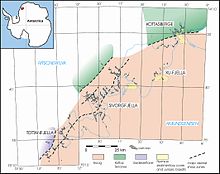
The Heimefrontfjella is a 150 km long mountain range in East Antarctica, which extends from about 13 ° to 9 ° 15'W and from 74 ° 15 'to 75 ° 15'S over an area of 3900 km² in a northeast-southwest direction. Heimefrontfjella is in the westernmost part of Queen Maud Land, claimed by Norway . The Heimefrontfjella is divided into four ice-free mountain parts by wide glaciers . From north-east to south-west, these are the Kottas Mountains ( norwegian Milorgfjella), XU-Fjella , Sivorgfjella and Tottanfjella .
geography
The Heimefrontfjella forms a highly articulated fracture step that dams the inland ice of the polar plateau at over 2200 m above sea level. The peaks of the mountains usually protrude only just above the polar plateau; steep, ice-free rock faces are mostly exposed to the north and northwest. The highest mountain is the Paalnibba with 2711 m. Heimefrontfjella is divided by three mighty glaciers into four mountain parts, each with its own name. The Haugebreen flows to the west between the Kottas Mountains and the XU-Fjella . The XU-Fjella is separated from the Sivorgfjella by the KK-Dalen. The glaciers unite at the foot of the mountains on the Aubertisen . The Kibergdalen lies between the Sivorgfjella and the Tottanfjella. In front of the mountains to the northwest is the glaciated, up to 1350 m high Ritscher highlands .
Discovery and exploration of Heimefrontfjella
Heimefrontfjella was sighted by the German Antarctic Expedition 1938/39 under the direction of Alfred Ritscher (1879–1963) during the first photogrammetric flight on January 20, 1939. However, the flight had to be stopped early due to poor visibility, and only the outlines of the northernmost part of Heimefrontfjella can be seen on the overview map of the expedition. The mountain range was named Kottas Mountains after the captain of the expedition ship MS Schwabenland , Alfred Kottas . During the Norwegian-British-Swedish expedition 1949-52 the mountains were flown over twice. On the basis of the resulting oblique aerial photographs , the Norsk Polarinstitutt created two topographical maps on a scale of 1: 250,000, which cover the northern and southern parts of the mountains, which Norway has renamed Heimefrontfjella .

In 1961 Heimefrontfjella was first reached by land by a British expedition that carried out a geodetic and geological program. British expeditions also took place in the following years up to 1966, the results of which were a geological overview map on a scale of 1: 250,000 and some basic publications on the geology and biology of these regions.
Since 1985/86 Heimefrontfjella has been the destination of German and Swedish expeditions. Swedish scientists carried out glaciological research, the German scientists focused on the geology and geophysics of the mountains. The geological work continued until the southern summer of 2000/01. Heimefrontfjella was the first mountain range in Antarctica to be completely geologically mapped on a scale of 1: 25,000.
Naming of geographic objects
The Norwegian name Heimefrontfjella means something like "Heimwehr Mountains" and is reminiscent of the Norwegian resistance in World War II . For example, the KK-Dalen and the XU-Fjella were named after the codes for Norwegian resistance groups operating underground. Other names were given in honor of the first British geodesists and geologists (e.g., itchy combs , bowrakammen , Ardusberget ). Two objects were named by German expeditions, the Wallnerspitze and the Weigelnunatak in the northern Heimefrontfjella. The name Kottasberge, given in 1939, was also used again on the satellite map published in 2001 for the northernmost part of the mountain range.
geology
Based on radiometric dating , the following geological units can be distinguished in Heimefrontfjella:
- a basement rock last deformed in the late Mesoproterozoic ;
- Parts of a Cambrian orogen in which the older components of the Mesoproterozoic orogen were deformed again and metamorphically overprinted;
- a locally preserved Permian overburden with plant fossils and thin coal seams;
- Basalt nappes and basalt veins dated to the middle Jurassic .
Metamorphic basement
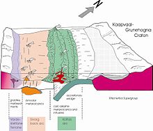
The Mesoproterozoic basement is well exposed in the Kottas Mountains of the northern Heimefrontfjella, so that the geological history there can be reconstructed. Banded gneisses dominate with a Trondhjemitic - tonalitic - dioritic composition, which are associated with several generations of coarse-grained metamorphic granites. The rocks were formed in a late Mesoproterozoic island arc ( Kottas Arc ) before 1200 to 1100 mya . For the central and southern Heimefrontfjella, a backarc basin characterized by extension and magmatism is assumed at the same time . The oceanic island arc lay south of the Kaapvaal-Grunehogna craton . About 1080 mya ago the Tugela Ocean between the arch of the island and the Kaapvaal-Grunehogna craton was closed and the rocks of the arch of the island were profoundly deformed and metamorphosed.
Only the eastern part of Heimefrontfjella was affected by mountain formation in the Cambrian , in which the rocks were again deformed and metamorphically overprinted. These mountains were formed as a result of the collision of East and West Gondwana , creating one of the largest mountain belts in the history of the earth, the East African-East Antarctic Orogen. The western limit of the Cambrian Mountains is marked by a shear zone several kilometers wide .
Sub-Permian overburden
After the formation of Gondwana in the Cambrian , Heimefrontfjella was eroded for a long time. Towards the end of the Carboniferous, there was a leveling area with minor differences in relief on which a thick ice sheet formed. Remnants of this area emerge in the northern Heimefrontfjella and show glacier scrapes and round humps . After the ice retreated, sediments were deposited, which started with diamictites at the base . A few meters of finely layered sandstones and siltstones with dropstones follow above the diamictites, followed by light-colored fine sands in which well-preserved leaf impressions can be found. This sequence represents the deposition of a delta in a periglacial lake. At Schivestolen, the highest peak of the Kottas Mountains, 140 m of yellowish sandstones with coal seams are still preserved. The age of the overburden could be limited to the Lower Permian ( Asselium to Sakmarium ) using palynological methods .
fauna and Flora
Heimefrontfjella has a lichen vegetation with 18 species that is typical of the continental Antarctica . Crusty lichens of the genera Lecidea , Acarospora , Lecanora and Xanthoria dominate . The leaf lichen umbilicaria also occurs in a few places . The mosses Sarconeurum glaciale and Grimmia sp. discovered, which also occur in other ice-free regions of Antarctica. The only known land creatures are three types of microscopic mites and one type of springtail . In Heimefrontfjella only a few pairs of the snow petrel Pagodroma nivea and the sku Stercorarius maccormicki, which lives on its eggs and young, breed due to the relatively large distance of 300 km from the coast .
Research stations
Currently (as of 2009) only Sweden operates a research station in Heimefrontfjella. The Svea station is at 74 ° 35′S and 11 ° 13′W at the exit of the Scharffenbergbotnen at 1245 m above sea level. Svea was built in the southern summer of 1987/88 and is only used as a summer station.
literature
- Alfred Ritscher (1942): Scientific and aeronautical results of the German Antarctic Expedition 1938/39 . 304 p., Koehler & Amelang, Leipzig.
- Lewis M. Juckes (1972): The geology of north-eastern Heimefrontfjella, Dronning Maud Land. British Antarctic Survey Scientific Report 65 , 44 pp.
- Joachim Jacobs (1991): Structural development and cooling history of the Heimefrontfjella (western Dronning Maud Land / Antarctica). Polar Research Reports 97 , 141 pp.
- Manfred Pietschmann (1990): The long way to Gondwana. Geo-Wissen 4 , pp. 30-41.
- Bauer, W., Jacobs, J., Fanning, CM & Schmidt, R. (2003): Late Mesoproterozoic arc and back-arc volcanism in the Heimefrontfjella (East Antarctica) and implications for the palaeogeography at the southeastern margin of the Kaapvaal- Grunehogna Craton. Gondwana Research 6 , pp. 449-465.
- Satellite map of Heimefrontfjella (PDF; 2.13 MB)
Web links
- Geological map 1: 250.000 on PANGEA doi : 10.1594 / PANGEA.727130
Individual evidence
- ^ Brunk, K. (1986): Cartographic works and German naming in Neuschwabenland, Antarctica. German Geodesic. Commission, Series E, 24 / I, 1–24. ( Memento of the original from June 26, 2011 in the Internet Archive ) Info: The archive link was inserted automatically and has not yet been checked. Please check the original and archive link according to the instructions and then remove this notice. (PDF; 391 kB)
- ^ Topographic map 1: 250,000 sheets D8 Heimefrontfjella Nord and D9 Heimefrontfjella Sør, Norsk Polarinstitutt, Oslo 1988
- ↑ Arndt, NT et al. (1987): The 2nd Neuschwabenland expedition to the Kottas Mountains. Reports on polar research 33 , pp. 134–158
- ↑ Bauer, W. et al. (1998): The geological map series 1: 25000 of Heimefrontfjella (East Antarctica) . Freiberg research books C 471 : pp. 24-26
- ^ Gjelsvik, T. (1989): Place-names of Heimefrontfjella and Lingetoppane, Dronning Maud Land, Antarctica . Norsk Polarinstitutt Rapporter 54 : 22S.
- ↑ Data sheet for the Wallnerspitze
- ↑ Data sheet for the Weigelnunatak
- ↑ house hold, A; Jung-Rothenhäusler, Frederik; Wintges, T (1997): Kottasberge, Satellite Image Map, 1: 100 000, Diploma Thesis, Alfred Wegener Institute for Polar and Marine Research, Bremerhaven & University of Applied Sciences Munich
- ↑ Plumstead, EP (1974): A new assemblage of plant fossils from Milorgfjella, Dronning Maud Land. British Antarctic Survey Scientific Report 83 , 1-30
- ↑ Rex, DC (1972): K-Age determinations on volcanic and associated rocks from the Antarctic Peninsula and Dronning Maud Land. In: Antarctic Geology and Geophysics , IUGS, B2, 133-136, Universitetsforlaget, Oslo.
- ^ Jacobs, J., Bauer, W. & Fanning, CM (2003): Late Neoproterozoic / Early Palaeozoic tectono-metamorphism in western central Dronning Maud Land (East Antarctica) and significance for the southern extension of the EAO into East Antarctica. Precambrian Res. 126 , 27-53.
- ↑ Larsson, K., Lindström, S. & Guy-Ohlson, D. (1990): An Early Permian palynoflora from Milorgfjella, Dronning Maud Land, Antarctica. Antarctic Science 2 , 331-344.
- ↑ Bowra et al. (1966): Biological Investigations in Tottanfjella and Central Heimefrontfjella . BAS Bulletin 9 , pp. 63-70. ( Memento of July 7, 2015 in the Internet Archive ) (PDF; 3.0 MB)
- ↑ List of Antarctic stations, Sweden's stations are marked with the abbreviation SWE ( MS Excel ; 79 kB) as of April 1, 2012


