Kottas Mountains
| Kottas Mountains | ||
|---|---|---|
| Highest peak | Schivestolen ( 2159 m ) | |
| location | Dronning Maud Land , East Antarctica | |
| part of | Heimefrontfjella | |
|
|
||
| Coordinates | 74 ° 19 ′ S , 9 ° 40 ′ W | |
| surface | 360 km² | |
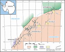
The Kottasberge are the northernmost, about 360 km² large mountain range of the Heimefrontfjella in Neuschwabenland . They consist of a central mountain massif, by two steep south Kare is divided and two Nunatak chains that extend from this massif to the east and southwest. The approximately 6 km long Nunatak chain in the east is called Arntzenrustene and consists of eight small Nunatakkers, the Nunatak chain in the southwest is about 14 km long and consists of 12 Nunatakkers. The highest peak is the 2159 m high Schivestolen in the central massif of the Kottas Mountains.
Discovery and naming
The Kottas Mountains were sighted by the German Antarctic Expedition 1938/39 during the first photogrammetric flight on January 20, 1939. However, the flight had to be canceled early due to poor visibility, which meant that only this part of Heimefrontfjella was sighted. The mountain range was named Kottas-Berge after the captain of the expedition ship Schwabenland , Alfred Kottas . During the Norwegian-British-Swedish expedition 1949-52 the area was flown over again and it was recognized that it was only the northern part of a larger mountain range. On the Norwegian topographic map at a scale of 1: 250,000, the northern part of Heimefrontfjella is called Milorgfjella , after the resistance organization Milorg . Since the federal government confirmed the German Antarctic Expedition's right to assign names to the discovery in 1938/39, the name Kottas Mountains has priority and is used again (in the new spelling Kottasberge ) on newer maps.
geology
see also Geology of Heimefrontfjella
The Kottas Mountains were systematically geologically explored and mapped in the southern summer of 1993/94 by a German-South African expedition . Geologically, the Kottas Mountains have some special features compared to the parts of Heimefrontfjella further south. The metamorphic basement was formed from an arch of the island that collided with the Grunehogna-Kaapvaal-Kraton about 1100 mya . In contrast to the other parts of Heimefrontfjella, this part of the mountain was not deformed and metamorphically overprinted again in the Cambrian . A fault zone marks the boundary of the Cambrian Mountains; this runs immediately south of the central massif of the Kottasberge and is exposed in the Nunataks Hasselknippenova and Lauringrabben . This crustal boundary is clearly visible on aeromagnetic images.
After a long period of erosion , sediments were only deposited again in the Permian . These contain well-preserved plant prints and traces of worm-like animals. Several thin coal seams are embedded in the up to 140 m thick sandstones .
Individual evidence
- ^ Brunk, K. (1986): Cartographic works and German naming in Neuschwabenland, Antarctica. German Geodesic. Commission, Series E, 24 / I, 1-24. ( Memento of the original from June 26, 2011 in the Internet Archive ) Info: The archive link was inserted automatically and has not yet been checked. Please check the original and archive link according to the instructions and then remove this notice. (PDF; 391 kB)
- ^ Topographic map 1: 250,000 sheets D8 Heimefrontfjella Nord, Norsk Polarinstitutt, Oslo 1988
- ↑ Milorgfjella in the SCAR Composite Gazetteer of Antarctica , accessed January 10, 2018
- ↑ Ritscher, A. (Ed.) (1952): Announcement about the confirmation of the designation of geographical terms made when "New Swabia" was discovered in the Atlantic Sector of Antarctica by the German Antarctic Expedition in 1938/39. (Official confirmation by the Foreign Office) - Bundesanzeiger 4, No. 149; 1-2; August 5, 1952; Bonn.
- ↑ house hold, A; Jung-Rothenhäusler, Frederik; Wintges, T (1997): Kottasberge, Satellite Image Map, 1: 100 000, Diploma Thesis, Alfred Wegener Institute for Polar and Marine Research, Bremerhaven & University of Applied Sciences Munich
- ↑ Thomas, RJ & Jacobs, J. (1994): The 1994 German International Expedition to east Antarctica. Episodes 17: 31-32.
- ↑ Jacobs, J. et al. (2002): Magnetic susceptibilities of the different tectono-stratigraphic terranes of Heimefrontfjella, western Dronning Maud Land, East Antarctica. Polar Research 72: 41-48. (PDF; 2.4 MB)
Web links
- Geological map 1: 25,000 sheets Vikenegga on PANGEA. doi : 10.1594 / PANGEA.138788
- Geological map 1:25 000 sheets Hanssonhorna on PANGEA. doi : 10.1594 / PANGEA.686061


