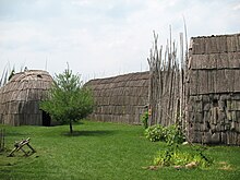
Tsiionhiakwatha / Droulers archaeological site interpretation center
The Tsiionhiakwatha / Droulers archaeological site interpretation center or Center d'interprétation du site archéologique Tsiionhiakwatha / Droulers is an interpretive center in the southwest of the Canadian province of Québec . It is located right next to a hill that houses a Saint Lawrence Iroquois village that existed around 1450.
The first part of the name means in the Mohawk language 'where we gather berries', the second part of the name is the family name of the farmer on whom the village is located and who has made the land available. The Interpretive Center was created on the initiative of the Mohawk Council of Akwesasne in collaboration with the Mohawk Nation Council of Chiefs and the Saint-Anicet community .
According to the results of the excavations, replicas of the houses are being built in the open-air museum , four of which (as of 2010) exist. In addition, there are furnishings and tools, fireplaces and clothes, toys and weapons, food plants and other items. The replicas are supposed to give an impression of the life of the Iroquois . The museum in the main building, where there is also a library, offers a small exhibition of archaeological finds.
The original village consisted of 15 long houses and lay on the river La Guerre in what is now the municipality of Saint-Anicet , right next to the museum. The small river flows further north into the St. Lawrence River . The settlement from the 15th century covered an area of about 13,000 m² and housed at least 500 to 800 people. It is the largest village ever found in Québec that dates from this period. 160,000 artifacts have been recovered to date . It is unclear when and for what reason it was abandoned; the residents may have fled from diseases that the French introduced from around 1535.
The site became public in 1974 when a farmer found a hatchet. In 1990 ceramic fragments were found. The first archaeological investigations were carried out in 1991, followed by the first excavation campaign in 1993. Construction of the first replicas of the houses began in 1997, and museum educational events have been taking place since 2001.
literature
- Roland Tremblay: Les Iroquoiens du Saint-Laurent. Peuple du mais , Les Éditions de l'Homme, 2006.
Web links
- Homepage (English / French)
- Virtual museum
- Film contribution from 2009 (French)
Coordinates: 45 ° 4 '53.8 " N , 74 ° 18' 54.5" W.

