Tuma (geography)

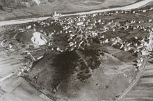
Tumas (plural feminine, sursilvan for "hill") denote the distinctive and landscape-defining earthfills in the area of Domat / Ems in the Chur Rhine Valley in the canton of Graubünden .
The total of twelve tumas originated in all probability from the fall energies of the Flims landslide , with whole packages being shipped. The fact that the Tumas are not erosion forms of the Rhine can be seen from the fact that cones are not a fluvial form of erosion and above all because the group stands like a bar at right angles to the direction of flow.
In addition, erosion does not explain the transport of the Vorderrheinischen material to Pardisla in Domleschg , i.e. along the Hinterrhein upstream.
Outside this region, elevations of this type are referred to as toma hills .
literature
- Jörger, Kaspar: Domat / Ems . A geographical and cultural-historical study, published by Hendri Spescha, Domat / Ems 1962
- Emil Kirchen: When the mountain falls: the landslide area between Chur and Ilanz . - Chur [etc.]: Terra Grischuna, cop. 1993. ISBN 3-7298-1087-1
Web links
reference
- ↑ Archived copy ( memento of the original dated July 6, 2011 in the Internet Archive ) Info: The archive link was inserted automatically and has not yet been checked. Please check the original and archive link according to the instructions and then remove this notice. (PDF file; 515 kB) AvPoschinger, Applied Geology, Vol. 11/2, in Chapter 5 on Bonaduz gravel as well as Tumas from Ems and the associated Tuma from Pardisla (Domleschg)
