Uedemerfeld
|
Uedemerfeld
Uedem municipality
Coordinates: 51 ° 40 ′ 14 " N , 6 ° 18 ′ 4" E
|
||
|---|---|---|
| Area : | 13.3 km² | |
| Residents : | 388 (Dec. 31, 2018) | |
| Population density : | 29 inhabitants / km² | |
| Incorporation : | 1st July 1969 | |
| Postal code : | 47589 | |
| Area code : | 02825 | |
|
Location of Uedemerfeld in North Rhine-Westphalia |
||
Uedemerfeld is a district of the municipality Uedem in the Kleve district in North Rhine-Westphalia . Uedemerfeld was an independent community until 1969 .
geography
Uedemerfeld is a systematically laid out Waldhufendorf with the Uedemerfelder Straße as a cultivation and settlement axis. The settlement does not have a compact village center, but consists of individual farms belonging to the peasant communities Persel, Kirsel, Uedemerfeld, Steinbergen and Bünnert. The natural eastern border from Uedemerfeld to the east adjoining Uedemerbruch is the old Grenzley drainage ditch .
history
Uedemerfeld was first mentioned on August 1, 1236 in a document from Count Dietrich V. von Kleve for a comparison with the Xanten monastery . The settlement was created by clearing the forest area east of Uedem. From about 1300 to the middle of the 18th century there was a jury, Uedemerfeld had its own jury.
Since the 19th century Uedemerfeld formed a rural community in the mayor's office Uedem (since 1928 Amt Uedem) in the Kleve district in the Düsseldorf administrative district . From 1906 to 1945 Uedemerfeld had a station on the railway line from Goch to Wesel , where agricultural goods and coal were loaded.
On July 1, 1969, Uedemerfeld was incorporated into the municipality of Uedem by the law on the reorganization of the district of Kleve .
Population development
| year | Residents | source |
|---|---|---|
| 1832 | 722 | |
| 1861 | 745 | |
| 1871 | 645 | |
| 1885 | 643 | |
| 1910 | 649 | |
| 1925 | 640 | |
| 1939 | 537 | |
| 2018 | 388 |
Architectural monuments
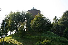
The most important monument in Uedemerfeld is the Hohe Mühle on the Katzenberg, which today serves as a meeting place and observation tower. The T-houses Kirsel 110 and Uedemerfelder Weg 21 are also under monument protection.
Culture
The St. Anna brotherhood , which is around 300 years old, exists in Uedemerfeld .
Individual evidence
- ↑ a b Details of the municipality of Uedem
- ↑ a b Details of the municipality of Uedem
- ↑ landscape Rheinland: Grenzley (drainage ditch)
- ^ Johann Georg von Viebahn: Statistics and topography of the government district of Düsseldorf. 1836, accessed on May 5, 2019 (digitized version).
- ^ Otto von Mülmann : Statistics of the government district of Düsseldorf. 1865, Retrieved May 5, 2019 .
- ↑ 1871 census
- ↑ Community encyclopedia for the Rhine Province 1885
- ↑ Uli Schubert: German municipality register 1910. Retrieved on February 2, 2017 .
- ↑ Rhine Province Community Dictionary 1930
- ^ Michael Rademacher: German administrative history from the unification of the empire in 1871 to the reunification in 1990. kleve.html. (Online material for the dissertation, Osnabrück 2006).


