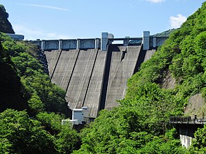
Urayama dam
| Urayama | |||||||||
|---|---|---|---|---|---|---|---|---|---|
| The dam | |||||||||
|
|||||||||
|
|
|||||||||
| Coordinates | 35 ° 57 '13 " N , 139 ° 3' 8" E | ||||||||
| Data on the structure | |||||||||
| Lock type: | RCC gravity dam | ||||||||
| Construction time: | 1972-1998 | ||||||||
| Height above foundation level : | 156 m | ||||||||
| Height of the structure crown: | 400 m | ||||||||
| Building volume: | 1.75 million m³ | ||||||||
| Crown length: | 372 m | ||||||||
| Power plant output: | 5 MW | ||||||||
| Data on the reservoir | |||||||||
| Altitude (at congestion destination ) | 393.3 m | ||||||||
| Water surface | 1.2 km² | ||||||||
| Storage space | 58 million m³ | ||||||||
| Catchment area | 51.6 km² | ||||||||
| Design flood : | 1 230 m³ / s | ||||||||
The Urayama Dam ( Japanese 浦 山 ダ ム , Urayama damu ) is a large dam in Japan. It stands on the Urayama River, a tributary of the Arakawa in Saitama Prefecture on the main island of Honshu . The barrier structure is a 156 meter high gravity dam made of rolled concrete , which was completed in 1998. The reservoir holds 58 million cubic meters of water. The main purpose is the flood protection on the Arakawa and the drinking water supply of Tokyo and other cities. There is also a recreational use. In addition, electricity is generated in a small hydropower plant.
literature
- Toshio Jōtatsu: Technical Results of Construction on Urayama Dam, Journal of Japan Society of Dam Engineers; ISSN 0917-3145 ; VOL.7; NO.3; Pp. 140-152, 1997, Japan
See also
- List of the largest dams on earth
- List of the largest reservoirs on earth
- List of the largest hydroelectric plants in the world
- List of dams in the world
Web links
Commons : Urayama Dam - collection of pictures, videos and audio files
- Toshio JOUTATSU: Technical Results of Construction on Urayama Dam , Dec. 17, 2012
- TAKIZAWA DAM and URAYAMA DAM , Japan Water Agency, PDF file 6109 kB, 19 Dec. 2012

