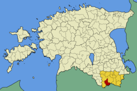
Varstu
| Varstu | |||
|
|||
| State : |
|
||
| Circle : |
|
||
| Coordinates : | 57 ° 38 ′ N , 26 ° 40 ′ E | ||
| Area : | 170.7 km² | ||
| Residents : | 1,036 (2017) | ||
| Population density : | 6 inhabitants per km² | ||
| Time zone : | EET (UTC + 2) | ||
| Website : | |||

|
|||
Varstu (German: Warsto ) is a rural community in the Estonian district of Võru with an area of 170.7 km². It has 1036 inhabitants (as of January 1, 2017).
Varstu is located in the southwest of the district on the border with Latvia . In addition to the main town of Varstu, the rural community includes another 18 villages: Hintsiko, Kangsti, Krabi, Kõrgepalu, Laurimäe, Liguri, Lüütsepa, Matsi, Metstaga, Mutemetsa, Paganamaa, Punsa, Pähni, Raudsepa, Soolätte, Tagakolga and Vana-Roosa.
Web links
- Varstu Municipality website (Estonian)
Individual evidence
- ↑ Website of the municipality (accessed on May 30, 2017)

