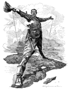
Cape Cairo plan

The Cape Cairo Plan is an unfinished project with the aim of crossing Africa from south to north with a rail link. This plan came into being at the end of the 19th century in the age of imperialism . Mainly the plan goes back to Cecil Rhodes , who wanted to connect the neighboring possessions of the British Empire by a continuous line from Cape Town in South Africa to Cairo in Egypt . Many sections of the railway could be put into operation. However, a large part is missing between Sudan and Uganda . As part of this project, the Boer republics were encircled by the colonies of Botswana and Rhodesia and the Boer War in what is now South Africa.
Reasons to build
The British colonialism in Africa is closely linked to the Cape to Cairo Railway. Cecil Rhodes was determined in favor of the plan to secure the southern states of the continent for the British Empire. He also dreamed of a continuous connection between the British Dominions . The railway line was supposed to unite property, facilitate administration, enable the military to arrive quickly at places of crisis or wage wars, support settlement and promote trade. Nonetheless, it was an enormous technical challenge to connect the entire African continent from north to south.
France had a competing strategy in the late 1890s. It wanted to network its African possessions from Senegal to Djibouti in a west-east direction. But Ethiopia and the southern part of Sudan were not in his possession. Therefore, France sent an expedition in 1897 with the aim of establishing a protectorate in southern Sudan and finding a route through Ethiopia. This project failed, however, when a British flotilla of the French expedition met at the intersection of the two routes on the Nile . In the further course of the Faschoda crisis , neither of the two nations was interested in a serious conflict and an amicable agreement was reached through diplomatic channels.
Reasons for non-completion
British ambitions not only had to overcome the hurdles of the continent and its climate, but also the disruptive interests of other powers. In addition to France, Portugal also tried unsuccessfully to link its colonies Angola and Mozambique . Furthermore, Germany had secured a large piece of land in East Africa , which prevented a north-south connection. But this gap could be closed, at least politically, with the German defeat in the First World War . Most of the former German territory fell to Great Britain as the Mandate Tanganyika . Between the world wars, economic issues prevented completion, even though the British Empire had the political power to do so. After the Second World War , the independence movements and decolonization made completion impossible.
Today's connections
The northern section
Egypt has had a railway system since 1856, which connects Alexandria with Cairo and which now goes on to Aswan in the south and was built in standard gauge . After a ferry crosses the Nasser Reservoir , a Cape Gauge route to Khartoum begins in Wadi Halfa in Sudan . This part of the line was put into operation in 1897 by Horatio Herbert Kitchener after the suppression of the Mahdi uprising . The southernmost point is the South Sudanese Wau . An extension and connection with the Ugandan and / or Kenyan railway network is being considered. A large part of the Sudanese route is currently falling into disrepair due to political unrest.
The construction of a rail connection from Ethiopia to South Sudan in standard gauge and from Kenya or Uganda to South Sudan in standard gauge is currently being planned again with Chinese help.
The route in Uganda
The East African railway lines historically run from the ports on the Indian Ocean to the west. These sections were expanded in parallel under German and British rule. The northernmost railway was the Uganda Railway , which was connected to the line started by the colonial powers, so that today there is a continuous railway connection between the Ugandan capital Kampala , the Kenyan city Mombasa and the Tanzanian capital Dar es Salaam . Until the breakup of the East African Community in 1977, these countries operated on the East African Railroad . Nowadays the routes are operated by various national companies. The track width is 1000 mm .
The TAZARA connection
In 1976, after six years of work, workers from the People's Republic of China were able to complete a 1,860-kilometer stretch in Kapspur (1067 mm) from Dar es Salaam to Kapiri Mposhi in Zambia . The TAZARA route was built to connect the landlocked state of Zambia with its mineral resources with the ports on the Indian Ocean without connections through South Africa or areas controlled by Portuguese at the time. However, this section was not intended in the Cape Cairo Plan.
The southern section
The southern section of the planned railway line was completed during the time of British rule. Work on this began in Cape Town and ran to Kimberley and then through eastern Botswana to Bulawayo . From this point it ran further north to the Zambezi . This part is now operated by the National Railways of Zimbabwe . The Victoria Falls Bridge was completed in 1905 and is then operated by a Zambian railway company. The route continues to Kapiri Mposhi, where it merges into the TAZARA. It was also built in Cape Gauge.
See also
literature
- George Tabor: The Cape to Cairo Railway & River Routes . London 2003.
- Paul Theroux: Dark Star Safari: Overland from Cairo to Cape Town . Houghton Mifflin, Boston 2004, ISBN 978-0-618-44687-2


