Ventersdorp (municipality)
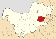
Ventersdorp was a municipality in the South African district of Dr Kenneth Kaunda in the Northwest Province . It was about 200 kilometers southwest of Johannesburg on National Road 14 . The administrative seat of the municipality was in the town of Ventersdorp . Nontetho Cilia Phoyane was the last mayor. The African National Congress last provided the majority in the local council.
The name of the municipality comes from the city of the same name. It was named after the farm owner Venter, on whose estate the town was founded. In 2011 the community had 56,702 inhabitants according to the census. It covered an area of 3764 square kilometers.
In 2016, the municipality was merged with the municipality of Tlokwe City Council to form the municipality of Tlokwe / Ventersdorp, since 2017 JB Marks .
Sons and daughters of the church
- Eugène Terre'Blanche (1941 or 1944–2010), South African politician
- Klaus Duschat (* 1955), German sculptor
Web links
- Information about Ventersdorp (English)
Individual evidence
- ↑ Gateway Ventersdorp ( English ) Retrieved April 6, 2010.
- ^ The Local Government Handbook - A complete guide to municipalities in South Africa. Ventersdorp Local Municipality (NW401). Yes! Media, accessed December 26, 2016 .
- ↑ South African Language - Place Names ( English ) Retrieved April 6, 2010.
- ↑ Municipal Demarcation Board - Gemeinde ( English ) Retrieved on April 6, 2010. ( Page no longer available , search in web archives ) Info: The link was automatically marked as defective. Please check the link according to the instructions and then remove this notice.
