Veriora
| Veriora | |||
|
|||
| State : |
|
||
| Circle : |
|
||
| Coordinates : | 58 ° 0 ′ N , 27 ° 21 ′ E | ||
| Area : | 200.3 km² | ||
| Residents : | 1,492 (01.2011) | ||
| Population density : | 7 inhabitants per km² | ||
| Time zone : | EET (UTC + 2) | ||
| Community type: | former rural community | ||
| Website : | |||

|
|||
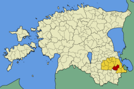
Veriora ( Eng . Paulenhof ) is a former rural community in the Estonian district of Põlva with an area of 200.3 km². It had 1,492 inhabitants (as of January 1, 2011). Veriora has been part of the Räpina rural community since 2017 .
In addition to the main town Veriora belonged to the municipality of the villages Haavapää , Himmiste , Jõevaara , Jõeveere , Kikka , Kirmsi , Koolma , Koolmajärve , Kullamäe , Kunksilla , Laho , Leevi , Lihtensteini , Männisalu , Mõtsavaara , Nohipalo , Pahtpää , Sarvemäe , Soohara , Süvahavva , Timo , Väike-Veerksu , Vändra , Vareste , Verioramõisa , Viira , Viluste , Vinso and Võika .
Veriora is 25 km from Põlva . The landscape is characterized by numerous forests, lakes and moors . Veriora Station gained notoriety as a marshalling yard for deportation trains during the Soviet occupation of Estonia. On September 28, 1978, the last Estonian forest brother , August Sabbe, died in the forest of Leevi .
Web links
- Veriora municipality website (Estonian)

