
Viðarlundin í Trongisvági


Viðarlundin í Trongisvági is a forest near the village of Trongisvágur on the Faroese island of Suðuroy . It consists mainly of spruce, pine and ash and is located about 1 km west of the village on the federal road 29 to Hvalba . The Faroese word viðarlund literally means "wood" and describes a park or forest in the Faroe Islands , of which only 0.06% is forested.
The Viðarlundin í Trongisvági forest extends over two very different sized plots. The larger of the two, corridor 152, is owned by the municipality of Tvøroyri (Tvøroyrar kommuna) and extends from the national road 29 in the north on both sides of the Rangá stream to the Við Rangá local road in the south. Between the main road and the Rangá, the property is overgrown with trees that were planted from the mid-1960s and cover an area of 28,700 m². A small branch of the Rangá flows through this part of the forest. Planting began after 2003 between the Rangá and the municipal road.
A part of the forest is located south of the Rangá on the property Flur 122c, which the Forest Authority (Skógfriðingarnevndin) of the Faroe Islands bought in 1974 to expand the forest and had trees planted. This part of Viðarlundin í Trongisvági is 1,793 m².
With a total area of (2003) 30,493 m², Viðarlundin í Trongisvági is the largest forest on the island of Suðuroy and one of the largest forests or parks in the entire Faroe Islands.
The Viðarlundin í Trongisvági is one of the largest forests of the Faroe a special attraction of the municipality Trongisvágur and the island Suðuroy. For the residents of the nearby town of Tvøroyri, it is a popular recreational destination with its barbecue area by the Stórá stream. Like all forests and parks in the Faroe Islands outside the capital Tórshavn , Viðarlundin í Trongisvági is also fenced in to protect the trees from sheep searching for food. It has several entrances and is criss-crossed by paved walking paths with benches. After 2003, it was expanded significantly to the south beyond the Stórá stream to the Við Rangá street , so that its area increased by 13,000 m² to 43,393 m². The area to be replanted is on a slope that slopes down towards the stream. From the newly built wooden bridge over the Stórá, a wide S-shaped driveway was laid to the new entrance gate in the south on the street mentioned. In 2014, the municipality of Tvøroyri (Tvøroyrar kommuna) bought a piece of land west of the existing forest and north of the Stórá stream in order to be able to enlarge the forest further.
With their cool, humid climate and salty air, the Faroe Islands are extremely unsuitable for trees to thrive, because the crust of the soil is relatively thin and tree roots offer little support. It is not uncommon for strong winds to blow, which can uproot trees, and it happens that the trees fall out in a mild January or February and are surprised in spring by suddenly falling frost.

View to the north with the bridge over the Stórá

Extension south of the Stórá
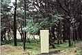
Deciduous trees in Viðarlundin í Trongisvági

Barbecue area at the Stórá

View of the older part of the forest from the south

View from the federal highway to the south


literature
- Andrias Højgaard, Jóhannes Jóhansen and Søren Ødum: Træplanting í Føroyum í eina øld , Føroya Fróðskaparfelag, Tórshavn 1989
Individual evidence
- ↑ Højgaard, Andrias: Træplanting í í Føroyum eina Old 47. Tórshavn 1989th
- ^ A b Højgaard, Andrias: Træplanting í Føroyum í eina øld , p. 41. Tórshavn 1989.
- ↑ Elttør, Eyðun : Uppskot til løgtingslóg um viðarvøkstur og frílendisrøkt , Tab. (Talva) 2, Løgting, March 4, 2003.
- ↑ Áargøtan í Trongisvági , visitsuduroy.fo
- ↑ Stórur áhugi fyri viðarlundum í Suðuroynni . Archived from the original on November 6, 2014.
- ↑ Gorsemann, Sabine: Färöer , p. 21f. Cologne 1999.
Coordinates: 61 ° 33 '48 " N , 6 ° 51' 53" W.