Vienenburg lake
| Vienenburg lake | ||
|---|---|---|

|
||
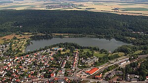
| Vienenburger See, aerial photo (2015) | ||
| Geographical location | Lower Saxony , Goslar , district Vienenburg | |
| Tributaries | Hurlebach | |
| Drain | Hurlebach | |
| Places on the shore | Vienenburg | |
| Data | ||
| Coordinates | 51 ° 57 '30 " N , 10 ° 33' 36" E | |
|
|
||
| Altitude above sea level | 133.7 m above sea level NHN | |
| surface | 17 ha | |
| length | 800 m | |
| width | 250 m | |
|
particularities |
Quarry pond |
|


The Vienenburger See is an artificially created lake in the Goslar district of Vienenburg in Lower Saxony . It is traversed by the Hurlebach, which flows into the Oker below the lake .
location and size
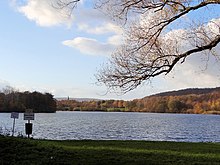
The lake is located between the village of Vienenburg and the Harlyberg in the Okeraue. The river runs below the Harlys and limits the lake to the north, partly only separated from the lake by a dam. The water level of the lake is 133.7 m above sea level. NHN and is thus lower than the location of Vienenburg and than the level of the inflowing Hurlebach with 140.7 m. The lake extends mainly in an east-west direction, the greatest length is about 800 m, the corresponding width is 250 m. In the west the bank structure is rather straight, while in the east there are natural bays and peninsulas.
The lake, which is partially surrounded by meadows, connects directly to the north of the Vienenburg settlement area and is integrated into the local structure as a local recreation area. The Vienenburg bathing establishment is also located there.
History of origin
In the city of Vienenburg, gravel had been mined since the 1920s, mainly by August Sievers & Co. This also operated a gravel pit in the area of today's lake. In the course of the catastrophic water ingress in the neighboring Hercynia potash works on May 8, 1930, there were further sinkholes between Vienenburg and Wiedelah , which had to be filled as quickly as possible. This took place through a less controlled mining in the area of today's lake. A floating dredger was also used for this, which could dig up to nine meters deep.
In the following decades, gravel mining was extended to the areas south of Wöltingerode, mining in the area of the lake was stopped in 1964 and the company was declared bankrupt in 1971. It left a devastated area of almost 15 hectares with water holes and numerous unsecured, up to seven meters high, steep banks on the outskirts, which were already used as a landfill. The city of Vienenburg was interested in the recultivation of the land, encouraged the development of a landscape conservation plan and bought the land and the adjacent meadows of the Wöltingerode monastery . In 1974 the site was formally declared a redevelopment area with the approval of the then regional president in Braunschweig. Vienenburg won the federal competition “Citizens are about your community” at state level. The construction of the later A 36 motorway directly on the Harly around 1972 benefited the project insofar as the high demand for gravel from Lake Vienenburg was met and the landscape was profiled at the same time. Cliffs were flattened and riparian zones created. The surface was partially covered with mud and planted. The lake got its present shape.
Todays use
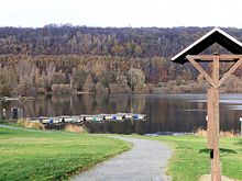
Near the inlet of the Hurlebach there is a jetty on the lake for boat operation with paddle boats and pedal boats, and there is also a café on the bank. A walking and hiking trail with benches runs around the lake, from which branches also lead across the Oker into the Harly.
The lake together with the Hurlebach is the fishing area of a local fishing club. In addition, the regattas of the local sailing club take place here, which has its own jetty on the west bank.
Web links
- Vienenburger See map display at openstreetmap.org
Individual evidence
- ↑ a b c d e State Office for Geoinformation and Rural Development Lower Saxony: Topographic map 1.25.000 Lower Saxony / Bremen , status 2014.
- ↑ Herbert Müller: History of the City of Vienenburg, 2nd historical illustrated book, Vienenburg until 1965 , 2nd edition Vienenburg 1999, p. 48 ff.
- ↑ a b c Herbert Müller: History of the City of Vienenburg, 3rd historical illustrated book, Vienenburg bis 2002 , Vienenburg 2002, p. 198 ff.
- ↑ Fishing Club Goslar am Harz. Retrieved July 18, 2015 .
