
Vratnik


Vratnik ( Serbian - Cyrillic Вратник ) is a district in the old town of Sarajevo and a district (mjesna zajednica) of the municipality of Sarajevo-Stari Grad . The district includes the old town Vratnik (Stari Grad Vratnik) surrounded by a city wall on the mountain slopes northeast of the old market district Baščaršija .
Since 2005, the entirety of the fortifications of Vratnik, built in the 18th century, has had the status of a National Monument of Bosnia-Herzegovina . Large parts of the city wall have been preserved to this day. The bastions now serve as popular lookout points.
geography
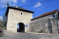
Vratnik is surrounded by a city wall, the corner points of which are the bastions Bijela tabija ("White Bastion") in the southeast, Žuta tabija ("Yellow Bastion") in the west and Strošićka tabija (also Crvena tabija , "Red Bastion") in the north. In the northeast, the bastion on the Zmajevac closes the fortifications. There are several city gates in the wall, both towards the city center ( Ploča and Širokac ) and out of town in the northeast ( Višegradska kapija ). The supraregional road towards Višegrad and further east to Istanbul ran through the latter gate before the Miljacka Gorge was opened up .
The entire walled district has dimensions of about 700 meters from east to west and about 950 meters from the northernmost to the southernmost point and an area of almost 50 hectares. The lowest point of the district Vratnik is on the southern edge in the Miljacka Gorge at about 565 meters above sea level, the highest point in the north on the Zmajevac hill (approx. 770 m).
The streets in Vratnik are usually very steep and relatively narrow. In many places they are designed as stairs due to the relief. Vratnik mejdan acts as the main street of the district , which leads from the town gate Širokac to Višegradska kapija and is the only real thoroughfare.
history
Already in the 15th century there was a fortification on the site of today's Bijela tabija, which secured access from the east into Sarajevsko polje. After the conquest of Bosnia by the Ottomans, there was initially no need to further fortify the deep inland city of Sarajevo. Only after the advance of Eugene of Savoy in the course of the Great Turkish War and the incursion of Austrian troops into the unfortified city on October 13, 1697, it was decided to build extensive fortifications. Construction began in 1729 under the Ottoman governor Gazi Ahmed-paša Rustempašić Skopljak, who had been in Sarajevo since 1727. Four bastions were built, including Žuta and Strošićka tabija . The three city gates were also completed by 1739. After 1816 another four bastions were added.
The old city fortifications were only able to delay the invasion of Austrian troops in 1878 by a few hours. Under Austrian rule, the outer bastions in Vratnik, facing away from the city, were included in the new fortification system. In 1886 the construction of the barracks in Vratnik (today Jajce kasarna ) began, the ruins of which still overlook the town. After 1945 the Yugoslav People's Army set up its own barracks on the northern edge of Vratnik, which is now used by the Bosnian army.
During the Bosnian War , Vratnik was under the control of the Bosnian government troops and was one of the districts that were enclosed during the siege of Sarajevo . Many historic residential buildings have been damaged or destroyed by shell bombardment and erupting fires.

Traditional Ottoman architecture in Vratnik
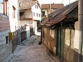
Narrow old town street
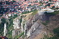
View from the south of the Bijela tabija, in the background Vratnik

City gate Širokac kula
City gate Višegradska kapija
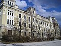
Jajce kasarna


Web links
- Kulturno nasljede kantona Sarajevo: Stari grad Vratnik. Retrieved March 13, 2017.
Coordinates: 43 ° 52 ' N , 18 ° 26' E