Vuata Ono
| Vuata Ono | ||
|---|---|---|
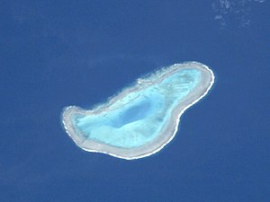
| NASA image by Vuata Ono | ||
| Waters | Pacific Ocean | |
| archipelago | Lau Islands | |
| Geographical location | 20 ° 44 ′ S , 178 ° 53 ′ W | |
|
|
||
| Number of islands | 0 | |
| length | 5.9 km | |
| width | 2.5 km | |
| Land area | 0 ha | |
| Lagoon area | 4 km² | |
| Residents | uninhabited | |
Vuata Ono , also Bereghis Reef , is a ring-shaped coral reef in the extreme southeast of the island state of Fiji in the Pacific Ocean .
geography
Vuata Ono is located 12 km southwest of Ono-i-Lau - the southernmost inhabited landmass of Fiji - in the Lau Archipelago . The atoll- like reef lies completely below the surface of the sea and has a length of almost 6 km and a width of up to 2.5 km. The lagoon , which is completely enclosed by a fringing reef, has an area of around 4 km². Vuata Ono gave its name to the Vuata Ono Marine Protected Area created in 1985 , a 7.5 km² marine reserve , which, however, includes the neighboring Atoll Ono-i-Lau.
Individual evidence
- ↑ Vuata Ono at geonames.org (English)
- ↑ Page of the Pacific Biodiversity Information Forum about the Vuata Ono Marine Protected Area ( page no longer available , search in web archives ) Info: The link was automatically marked as defective. Please check the link according to the instructions and then remove this notice. (English)

