Lau Islands
| Lau Islands | ||
|---|---|---|
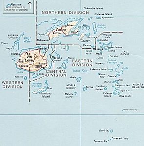
| Map of Fiji, the Lau Islands in the southeast | ||
| Waters | Koro lake | |
| archipelago | Fiji | |
| Geographical location | 18 ° 20 ′ S , 179 ° 20 ′ W | |
|
|
||
| Number of islands | 100 | |
| Main island | Lakeba | |
| Total land area | 487 km² | |
| Residents | 9602 (2017) | |
| Satellite image of part ( Yagasa Cluster ) of the Lau Islands | ||
The Lau Islands (also Lau Archipelago , Lau Group or Eastern Islands ) are an archipelago belonging to the Pacific State of Fiji in the southern Pacific . They form one of the 14 provinces of Fiji and are part of the Eastern Division of the country.
The approximately 100 islands, of which only about 30 are inhabited, extend east of the Koro Sea from north to south over almost 1000 km, the total land area is 487 km². The Vuata Ono Marine Protected Area is a 7.5 km² marine nature reserve. The largest and most important islands of the archipelago are, from north to south:
In the Northern Lau Group
- Yacata is the only Lau Island that belongs to the Northern Division
- Naitaba
- Vanua Balavu , main island
- Kanacea
- Vatu Vara
- Mago
- Tuvuca
- Cicia
- Nayau
- Cakau Tabu (uninhabited, known for giant clams )
In the Southern Lau Group
- Lakeba , main island
- Vanua Vatu
- Olorua
- Oneata
- Moce
- Komo
- Namuka-i-Lau
- Vuaqava
- Kabara
- Yagasa
- Fulaga
- Ogea
- Vatoa
In the Moala Group
Isolated in the extreme south
The population has decreased, from 12,211 (1996 census) to 10,683 (March 2007 census) and most recently 9602 (2017 census). The main town is Tubou on the island of Lakeba.
Web links
- Detailed map of Fiji (PDF; 6.6 MB)
- The Lau Islands in the EthnoAtlas (English)
Individual evidence
- ↑ Fiji Islands Bureau of Statistics ( Memento of September 9, 2015 in the Internet Archive ) - Population 2007 Census, p. 20. (PDF; English)
- ↑ Census 2017. In: statsfiji.gov.fj. Fiji Bureau of Statistics, March 5, 2018, archived from the original on March 20, 2018 ; accessed on March 23, 2018 (English).


