Mago (island)
| Mago (Mango) | ||
|---|---|---|
| NASA Geocover 2000 satellite image | ||
| Waters | Pacific Ocean | |
| Archipelago | Lau Islands / ( Fiji Islands ) | |
| Geographical location | 17 ° 27 ′ 0 ″ S , 179 ° 9 ′ 0 ″ W | |
|
|
||
| length | 5.4 km | |
| width | 5.3 km | |
| surface | 22 km² | |
| Highest elevation | 204 m | |
| Residents | 35 1.6 inhabitants / km² |
|
| Mago in the north of the Lau Islands | ||
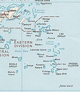
Mago , and Mango is a island of volcanic origin in the north of about Fiji belonging Lau Islands located. The 22 km² island is one of the largest private islands in the Pacific . The island is about 20 km southwest of Vanua Balavu , to which most of the original inhabitants were displaced during the nineteenth century, 15 km south of Kanacea and 24 km northeast of Cicia . The island reaches a height of 204 meters above sea level.
history
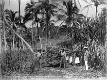
In the mid-nineteenth century, a cotton plantation was established on the island and the local Melanesian population was expelled. In 1884, sugar cane was grown on Mago with the help of Indian workers and processed in a mill, which was dismantled in 1895 to add to a larger mill on a neighboring island. After sugar cane cultivation became unprofitable, the new owners of the island began to produce copra , which should prove to be profitable in the long term. The owner family Borron donated a hotel in Suva to the government of Fiji , which is now used as a guest house for state guests.
today
In 2005 the island was bought by Hollywood star Mel Gibson from the Japanese transport company Tōkyō Kyūkō Dentetsu . Today, the few Fiji Indians still living here do little arable farming .
There is a small, unpaved airfield on the island with a 1,100 meter long runway.
Individual evidence
- ↑ Sailing Directions (enroute), Pub. 126, Pacific Ocean (PDF; English; 4.84 MB)
- ↑ Article in BBC News (English)


