Moce
| Moce | ||
|---|---|---|
|
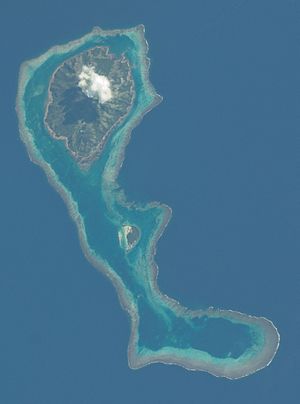
NASA astronaut picture of Moce, with Karoni (center) and the annular reef Na Potu (below) |
||
| Waters | Koro lake | |
| Archipelago | Lau Islands | |
| Geographical location | 18 ° 39 ′ 0 ″ S , 178 ° 30 ′ 20 ″ W | |
|
|
||
| length | 4.5 km | |
| width | 3.7 km | |
| surface | 11 km² | |
| Highest elevation | 180 m | |
| Residents | about 600 55 inhabitants / km² |
|
| main place | Nasau | |
Moce even Mothe , is an island of volcanic origin in the island state of Fiji belonging Lau archipelago .
geography
Moce is in the Southern Group of the Lau Islands; Neighboring inhabited islands are Komo , 12 km to the west, Oneata , 19 km to the north, and Namuka-i-Lau, 22 km to the south-west . The approximately round island is 4.5 km long and up to 3.7 km wide. Its area can be estimated at around 11 km² and it reaches a height of 180 m above sea level. Moce is almost completely surrounded by a fringing reef that extends far to the south and also borders the small, uninhabited island of Karoni and continues in the extreme southeast in the ring-shaped coral reef Na Potu , on which, however, there are no islands.
administration
The island belongs administratively to the Eastern Division of Fiji and forms one of the 13 traditional districts ( tikina ) of this province. There are two villages ( koro ) on the island with a total of around 600 inhabitants, Korotolu and Nasau , both on the south coast.
Web links
- Detailed article about Moce by the Max Planck Institute for the History of Science (PDF; English; 572 kB)
- Landsat satellite image
Remarks
Individual evidence
- ↑ Sailing Directions (enroute), Pub. 126, Pacific Ocean (PDF; English; 5.1 MB).
- ↑ Entry at geonames.org (English).

