Macuata
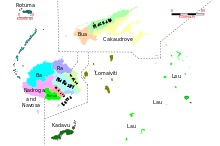
Macuata is one of the fourteen Fijian provinces (yasana) and one of the three provinces on the island of Vanua Levu .
geography
The province is located in the northwest of the island and covers approx. 40% of the island's area, approx. 2004 km². The province has numerous small rivers and the north coast of the island is characterized by small offshore islands and a barrier reef. About 20 km north of the eastern tip is the island of Thikombia .
114 villages in the province are divided into 12 districts (tikina): Dreketi , Macuata, Seaqaqa Sasa , Wailevu , Labasa , Mali , Nadogo , Namuka , Dogotuki and Udu (from W to O). In 2017, 65,983 inhabitants were counted. In terms of population, this makes the province the fourth largest in Fiji. More than a quarter of the population lives in the city of Labasa (24,187 in 1996).
The Macuata district lies in the west of the province ( ⊙ ). The 1997 constitution established two constituencies: Macuata Fijian Provincial Communal (for indigenous people) and Macuata East Cakaudrove Indian Communal (for Indian immigrants). With the fourth Constitution of Fiji 2013, all constituencies were amalgamated.
See also
Individual evidence
- ↑ Macuata at geonames.org.
- ↑ rsis.ramsar.org : Macuata Province Natural Resource Management Strategy 2014–2018: 12.
- ↑ Fiji Bureau of Statistics: 2017 Population and Housing Census - Release 1 . In: Census 2017 . January 5, 2018. Retrieved April 8, 2018.
- ↑ Macuata District at geonames.org.
Web links
- WWF : Macuata Province Leads with Natural Resource Management Strategy. 22nd August 2012
- rsis.ramsar.org : Macuata Province Natural Resource Management Strategy 2014–2018.
- wwfpacific.org : SPREP and WWF seal partnership for environmental work in Macuata province, Fiji. July 31, 2018.
Coordinates: 16 ° 26 ' S , 179 ° 22' E
