
Tempelhofer Berg water tower

The Tempelhofer Berg water tower (alternative names are water tower Kreuzberg , water tower Kopischstraße and water tower Undine ) is a former water tower for the drinking water supply in the Berlin district of Kreuzberg on the corner of Fidicinstraße and Kopischstraße. It was built from 1887 to 1888 and is now a listed building.
history
In January 1886, an architectural competition was announced among the members of the Berlin Architects' Association for a water lifting system planned by the “Curatorium of the municipal waterworks” on the Tempelhofer Berg, an extension of the Kreuzberg. The system should consist of a tower, a boiler and coal house, a chimney, a scale for the delivery of coal and an enclosure. In addition to the water tank, the tower was supposed to house an apartment for the machinist as well as machines and pump room. The architects Hugo Hartung and Richard Schultze received the first prize on February 22nd, 1886 for their design, which they had submitted under the motto “Undine”. Construction of the facility began in April 1887 and the shell was completed in October 1887. In May 1888 the construction work was completed and on June 14, 1888 the building handover took place.
The architecture of the ensemble is based on medieval brick Gothic . Silesian granite was used in addition to the bricks in the base area and for the steps . Plastered panels , cornice strips and sintered bricks rising up in a spiral shape served as structural decoration . The tower as the main element of the ensemble stands directly on the street corner. The chimney and stairwell nestle against the tower as separate components. The outbuildings with the boiler room and storage facilities are located along Fidicinstrasse. All buildings are covered with slate , the tower and stairwell each received a pointed conical roof . The engine room on the first floor of the tower was decorated with a later walled-in star vault with ribs made of shaped bricks . This vault therefore has no static function. The tower has a height of 44.4 meters.
The facility was necessary in connection with the settlement of the higher-lying areas around today's Chamissoplatz . For this purpose, a higher-lying water depot was necessary in order to achieve the necessary pressure in the water pipes. The water tank had a volume of 400 cubic meters and the system had a water supply capacity of 2000 cubic meters per day.
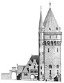
View from the courtyard
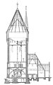
Longitudinal section through the plant

Floor plan of the apartment in the tower


In 1925 there was a switch from steam engines to electric motors as the energy supply for the pumps. In 1955 the plant was shut down.
In 1982 the property became the property of the Kreuzberg district, which carried out extensive renovation of the buildings between 1986 and 1988. In addition, the ensemble was converted into a youth and leisure facility according to plans by the district's structural engineering department. Many original components such as the water tank, the granite spiral staircase or the star vault have been preserved.
literature
- Richard Schultze: Municipal water lift for the southwest of Berlin. In: Zeitschrift für Bauwesen , Volume 38 (1888), Issues VII to IX, Sp. 285–288
supporting documents
- ↑ a b Entry in the Berlin State Monument List
- ↑ A competition for the design of a small water lift on the Kreuzberge in Berlin. In: Centralblatt der Bauverwaltung , Vol. 6, No. 2 (January 9, 1886), p. 16.
- ↑ Competition for designs for a water lift on the Kreuzberg near Berlin. In: Centralblatt der Bauverwaltung , Vol. 6, No. 9 (February 27, 1886), p. 88.
- ↑ a b Richard Schultze: Municipal water lift for the southwest of Berlin. In: Zeitschrift für Bauwesen , Volume 38 (1888), Issues VII to IX, Sp. 285–288
- ^ Jens U. Schmidt: Water towers in Berlin. Regia-Verlag, Cottbus 2010, ISBN 978-3-86929-032-4 , p. 23
- ↑ a b c Berlin and its buildings: Stadttechnik. (= Part X, Volume A (2)) Michael Imhof Verlag, Petersberg 2006, ISBN 978-3-86568-012-9 , p. 354
- ^ Jens U. Schmidt: Water towers in Berlin. Regia-Verlag, Cottbus 2010, ISBN 978-3-86929-032-4 , p. 24
Web links
- Entry in the Berlin State Monument List with further information
- DTK water tower; Youth, culture and communication center
Coordinates: 52 ° 29 ′ 13.7 " N , 13 ° 23 ′ 22.7" E