
Waw an-Namus
| Waw an-Namus | ||
|---|---|---|
 Waw an-Namus, taken from the space shuttle , October 25, 1992 |
||
| height | 547 m | |
| location | Libya | |
| Coordinates | 24 ° 55 '5 " N , 17 ° 45' 45" E | |
|
||
| Type | Caldera | |


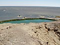
Waw an-Namus ( Arabic واو الناموس, DMG Wāw an-Nāmūs 'mosquito crater'; also Wau-en-Namus ) is an extinct volcano , a caldera in southern Libya , near the geographic center of the Sahara .
At the bottom of the approx. 4 km wide and 100 m deep caldera there is a cinder cone and three salt lakes , all of which appear in different colors. These lakes justify the naming of the Waw an-Namus. Around the caldera there are 10–20 km of fields with dark volcanic loose material ( tephra ), which can even be clearly seen from space.
Waw an-Namus has enjoyed increasing tourist popularity since Libya began to open to tourism from around 2000. Since the beginning of the civil war in February 2011, the tour to Wau-en-Namus is no longer possible because of the extremely unsafe situation in Libya since then.
On the southern edge of the Tibesti Mountains , about 500 km as the crow flies, is the spectacular “Natronloch”, Trou au Natron .
Picture gallery

Waw an-Namus

blue groundwater lake
green lake

red lake


Individual evidence
- Waw an-Namus in the Global Volcanism Program of the Smithsonian Institution (English)
- Fascination with volcanoes: Photos February 2011