
Tibesti
| Tibesti | ||
|---|---|---|
 Emi-Koussi Summit observed from the International Space Station |
||
| Highest peak | Emi Koussi ( 3415 m ) | |
| location | Chad | |
|
||
| Coordinates | 20 ° 47 ' N , 18 ° 3' E | |
| particularities | highest mountains in the Sahara | |
 Landscape in the Tibesti east of Bardai |
||

The Tibesti is a mountain range in Chad consisting of volcanoes and at the same time the highest mountain range in the Sahara . Its northern foothills extend several hundred kilometers into the territory of Libya . It rises on the northern edge of the Chad Basin and rises from the flat desert landscape with several layers. The high mountains are partly very rugged and show numerous volcanic craters and cinder cones . The Tibesti is one of the most isolated regions on earth and is populated by the Tubu . The regional administrative center is the cityBardaï with around 1500 inhabitants.
Geography and geology
The Tibesti Mountains cover an area of around 100,000 km² and extend from the 19th to the 23rd northern latitude and from the 16th to the 19th eastern longitude. The very strong volcanic activity can serve as an example of the formation of continental rift systems. Its formation began in the early Miocene and lasted into the Quaternary . The rift does not seem to expand any further and has passed the zenith of its volcanic activity, as there are frequent calderas and collapsed magma chambers in this area , which no longer fill up and have left numerous crater systems.
topography
The Tibesti volcanoes determine the topography of the mountain range and are among the continental rift volcanoes, of which at least three volcanoes and one volcanic field have been described as active or potentially active . Due to its remote location, active volcanic activity was not discovered from space until the 1970s, when a Soviet satellite from the Kosmos series observed an eruption in the Yi Yerra hot spring field on the southern slope of Emi Koussi .
Due to its height, the mountains receive more rainfall than the surrounding area. The highest peak is the Emi Koussi volcano at 3445 meters. Other volcanoes are the Tarso Toussidé with 3265 meters, the Tarso Voon with 3100 meters and the Tarso Toon with 2625 meters. The extensive volcanic field Tarso Toh lies in the western part of the mountain range . The salt deposits in the Caldera Era Kohor des Emi Koussi and in the Caldera Trou au Natron southeast of the Tarso Toussidé are of regional economic importance .
In the central part of the Tibesti, near the Tarso Voon, there is the Soborom solfatar field , which the local population visits for medical purposes.
The 2267 meter high Bikku Bitti lies on the territory of Libya and flattens into the desert plain of Libya after the 1650 meter high Jabal Nuqay .
In the north of the Tibesti is its only freshwater lake, the Mare de Zoui , which is a few hectares in size.
history
Less is known about the settlement history of the Tibesti than about other high mountains in the Sahara. The difficult security situation has prevented archaeological research here for a long time. What is certain is that the Tibesti is a regional climatic favored area that has been continuously inhabited since the Stone Age . The settlement of Gabrong near Bardai dates back to around 6100 BC. BC back.
Prehistoric rock art is known from various places in the form of engravings and paintings . From the earliest phase, from around 8000 BC. Chr., Large engravings are of wild animals. The most important regional find for this is the Enneri Gonoa. The so-called "Man of Gonoa" is one of the most famous motifs of the Eastern Sahara. In the later phases, polychrome paintings appear increasingly . First of all, v. a. Cattle, later also camels and armed warriors.
From the third millennium before the turn of the era, there are monumental grave structures whose floor plan is teardrop-shaped and up to 50 m long. It is not known who built it. Herodotus calls in the 5th century BC The troglodytes as southern neighbors of the Libyans. The first wave of immigration by the Tubu is dated around the same time and was reinforced by later thrusts.
Naming
Many of the names used in the Tibesti region come from Arabic and the Tedaga and Dazaga languages, which belong to the group of Saharan languages . The term Ehi is used for mountain tops or hills with steep slopes. Emi is used for larger mountains, but also for mountain ranges; the term Tarso is used for high plateaus or mountains with mountain slopes that have a slight gradient. The term Ehra is used for volcanic craters and calderas. In the standard literature on the volcanoes of the Tibesti, however, these indigenous names are rarely used or, apart from a few examples, are used correctly, such as the Emi Koussi and the Tarso Toh.
climate
The mountainous region of the Tibesti belongs to the arid climate type . The annual amount of precipitation is given as less than 600 mm per year. The area can only feed a few inhabitants, for this reason the Tibesti is nicknamed "Mountainous Country of Hunger" (see below: Werner Gartung). The known maximum temperatures are around 30 ° C in the lowlands and around 20 ° C in the high areas of the mountains. In the winter months, however, this falls to around 12 in the lowlands and 9 ° C in the high areas.
flora
The vegetation in the mountains of the Tibesti varies with the altitude and the gradient. In the south-western mountain slopes that are wadis Enneri Tegaham, Enneri Mi, Enneri Ké leading surface water at greater precipitation and the growth of trees such as the hyphaene ( Hyphaene thebaica ), the toothbrush tree ( Salvadora persica ), tamarisk ( Tamarix articulata ), the faidherbia albida ( Acacia albida ) and other tropical plants made possible by Abutilon , Hibiscus and Tephrosia .
In the higher elevations of the mountains, the endemic Ficus teloukat grows on the south and south- west slopes, the Myrtus nivellei on the western slopes and Tamarix gallica nilotica on the northern slopes .
fauna
Larger mammals in the mountains include the Dorcas gazelle (Gazella dorcas) , the barbary sheep (Ammotragus lervia) and the cheetah (Acinonyx jubatus) . Populations of smaller mammals include the rock hyrax (Procavia capensis) , the kaphase (Lepus capensis), and the spiny mouse (Acomys spp) .
Research history
- Tibesti - The discovery of the giant craters and the first crossing of Sudan - 1868–1874 , Ed. Heinrich Schiffers , Horst Erdmann Verlag, Tübingen and Basel, 1978 ISBN 3-7711-0305-3
Picture gallery

Formation of the Tibesti volcanic region

Tousside Peak (1992)

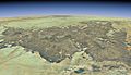
Satellite image of the Tibesti (2010)
Emi Koussi in Tibesti, (2011)

The inner crater of Emi Koussi (2010)
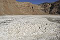
The inner crater of Emi Koussi ; Mineral deposits on the bottom (2010)


literature
- Werner Gartung : Yallah Tibesti. From Lake Chad to the rock people. Westermann, Braunschweig 1992, ISBN 3-07-509400-5 .
- Jan Kuper, Peter Schönfeld: Expedition to Tibesti - research in the highest mountains of the Sahara. Heinrich-Barth-Kurier 1/2015, 18–21.
- Jan Kuper, Peter Schönfeld, Stefan Kröpelin: Newly discovered prehistoric grave structures at Emi Koussi, Tibesti Mountains (Chad). , Communications from the Sudan Archaeological Society in Berlin eV special issue 2017, 35–42.
- Jason L. Permenter, Clive Oppenheimer: Volcanoes of the Tibesti massif (Chad, northern Africa). (PDF; 768 kB).
- Christoph Staewen : A trip to Tibesti. Richter, 2005, ISBN 3-00-015063-3 (travel report from spring 1964).
- Boundaries of Lake Chad Region , UNEP publication, p. 26 (PDF; 8.4 MB).