
Emi Koussi
| Emi Koussi | ||
|---|---|---|
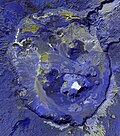
 Emi Koussi seen from space |
||
| height | 3415 m | |
| location | Chad | |
| Mountains | Tibesti | |
| Coordinates | 19 ° 47 '37 " N , 18 ° 33' 7" E | |
|
||
| Type | Pyroclastic shield volcano | |
| Age of the rock | Holocene | |
| Last eruption | Unknown | |

Emi Koussi (also known as Emi Koussou) is a tall pyroclastic shield volcano at the southeastern end of the Tibesti Mountains in the central Sahara , in the northern Borkou region of northern Chad . The highest mountain in the Sahara is one of the few volcanoes of the Tibesti and reaches a height of 3415 meters. It rises 3 kilometers above the sandstone plain around the volcano, has a diameter of 60-70 kilometers and has a volume of 2500 cubic kilometers.
Two overlapping calderas form the top of the volcano, the outer one is about 15 by 11 kilometers wide. Inside this caldera, on the southeast side, is a smaller caldera known as Era Kohor; this is 2 kilometers wide and 350 meters deep. In the calderas and on the flanks of the shield there are several ash cones , lava flows , maars and spring crests . Era Kohor contains Trona deposits , and Emi Koussi has been studied as an analogue of the Martian volcano Elysium Mons . Emi Koussi was active over a million years ago, but some eruptions could be more recent, so both fumaroles and hot springs are present.
Geography and geomorphology
Emi Koussi is located in Chad and is part of the Tibesti Mountains, its highest peak and thus also that of the entire Sahara; many peaks in Tibesti are higher than 2000 meters. The volcanism of the Tibesti has hardly been researched because the region is remote and access is difficult for political reasons. According to reports, the Tubu lived in its summit caldera and in man-made caves. In the Tedaga language, "Emi" means "mountains", " massive ".
The Emi Koussi reaches a height of 3415 meters on its southern side, it rises three kilometers above the surrounding area. Some astronauts refer to Emi Koussi as the most striking structure on earth from orbit . It is said that the entire Tibesti can be seen from the northern peaks of Emi Koussi.
It is a shield volcano with a diameter of 60–70 kilometers and an assumed volume of 2500 cubic kilometers. The tip of Emi Koussi is formed by two overlapping calderas, which together form a 15 × 11 kilometer wide elliptical caldera, which extends in a northwest-southeast direction. The northern caldera was formed first, then came the southern caldera, which is 50 meters below the northern caldera. 400-300 meter high rock walls form the inner edge of the southern caldera, the bottom of which is at an altitude of 2970 meters. Before the calderas formed, the volcano may have reached a height of 4,000 meters. A valley drain cuts through the edge of the caldera, the Porte de Modiounga .
Within this pair of caldera lies the Era Kohor caldera, which is 300 meters deep and 2 kilometers wide and looks like a huge hole. This caldera is also known as the Natronloch or Trou au Natron . Trachyte lava flows are exposed in its walls, and sodium carbonate has deposited on its bottom, which is at an altitude of 2670 meters and contains a salt lake. The bottom of Era Kohor is therefore pure white. Three maars and some cinder cones also occur within the caldera complex, accompanied by lava flows and spring crests . Ejection of an explosive eruption fills the calderas.
The Kohor pumice and two ignimbrites cover the slopes of the Emi Koussi, which become steeper towards the summit. Cinder cones on the slopes are accompanied by lava flows. At the top of the volcano, the lava is furrowed by crevices known as "Lappiaz". Sandstone is exposed in the terrain around the volcano . To the north of the Emi Koussi are other volcanoes such as Tarso Ahon and Tarso Emi Chi , the former is connected to Emi Koussi by a narrow ridge.
geology
Tectonic events took place in the Tibesti Gerbirge between the Carboniferous and the Cretaceous , i.e. between 358.9 ± 0.4 and 66 million years ago. In the early phase of the Tibesti volcanism, alkali basalt formed wide plateaus. Central volcanoes later formed on these plateaus. Volcanism in Tibesti has been explained with a mantle plume as in other African volcanoes, but it has recently been suggested that the effects of the collision between Europe and Africa may be responsible for Tibesti volcanism.
The oldest rocks below the Tibesti are Precambrian diorites , mica schists and granites , which probably come from the Neoproterozoic and are divided into two units. The volcanic rocks rest on a raised base made of Cretan and Paleozoic sandstone . The latter are exposed at the southwestern foot of Emi Koussi, while volcanic rock dominates north of the volcano and the Tibesti massif in the east and southeast of Emi Koussi. Older volcanic rocks appear in valleys.
The Emi Koussi mined phonolite , trachyandesite and trachyte , but also mafic rocks such as basanite and tephrite . The extracted rocks define basic volcanic families. The chemistry of the prisoners and their composition varies between the different rocks; among the minerals are alkali feldspar , amphibole , biotite , clinopyroxene , olivine , oxides and plagioclase . Alkali feldspar, apatite , clinopyroxene, olivine, magnetite , mica , nepheline , oxides, plagioclase, quartz , sodalite , titanite and zircon also form the basic mass of microliths in extracted rocks. Fractional crystallization was primarily involved in the formation of the magma . Emi Koussi stones were used as raw material by regional Neolithic societies .
In the early Holocene , the Era Kohor was filled by a circular, deep lake. Diatomeenablagerungen were 125 meters above the bottom of the Era Kohor found and in sinks without drainage elsewhere in the caldera, they reach thicknesses of 4-5 meters. Further down the mountain, erosion channels appear from an altitude of 2,800 meters and deep gorges become deep gorges from an altitude of 2,000–2500 meters . The Wadi Elleboe has its origin on the Emi Koussi, and some episodic streams on the western flank lead into the Enneri Miski, which drains south and disappears south of the mountains. Small lakes can be found around Emi Koussi.
Activity chronology
The Emi Koussi erupted between 2.4 and 1.3 million years ago; he is considered to be a Pliocene to Quaternary age. The volcano formed in advance in the Miocene in a time frame of about a million years. Radiometric dating has shown ages of 2.42 ± 0.03 - 2.33 ± 0.09 million years for the oldest stage of Emi Koussi. The third stage gave ages of 1.4 ± 0.3 - 1.32 ± 0.2 million years; previously the Era Kohor was understood as a Holocene volcano.
In the first stage, trachyte and trachyandesite broke out of the Emi Koussi in the form of ignimbrites and basaltic lapilli . This was followed in the second stage by trachytic, gray or green ignimbrites, spring domes made of trachyte or phonolite and additional lava flows made of basalt. The second stage ignimbrites are found in the northern caldera and on the southern flank of the volcano. In the third stage, phonolite was mined in advance, in the form of breccias , tuffs and ignimbrite including Kohor ignimbrite. The various ignimbrites contain flames and often look like lava flows. A caldera was formed during each stage, and all three stages were accompanied by basaltic volcanism. Phreatic explosions of the Era Kohor left large rocks in the summit caldera, including splendidly colored syenite blocks.
Quaternary volcanism has formed cones on the slopes of Emi Koussi, and within the summit caldera the three maars represent the most recent volcanism, while long lava flows are considered to be the youngest volcanic products of Emi Koussi. The youngest volcanic formations are little eroded. Erosion occurred on the flanks of the Emi Koussi in the early Pleistocene , and carbonates have been deposited in the Era Kohor until recently .
At the southern foot of the volcano there are fumarolic phenomena like at Yi Yerra at 850 meters altitude on the south side. At Yi Yerra, 37 ° C warm water flows from thermal springs . The Emi Koussi is considered to be a volcano of the Holocene Age. In its caldera, diatom deposits from the Holocene have been overflowed by lava flows; the radiocarbon method determined ages of 14,790 ± 400 - 12,400 ± 400 years for the diatom deposits buried or affected by lava flows.
Climate and vegetation
In the Tibesti Mountains there is a mountain desert climate. Near the Emi Koussi there are no weather stations and stations at lower altitudes most likely underestimate the precipitation at higher altitudes, but an annual precipitation of 80–120 millimeters per year for the Emi Koussi has been derived from the degree of cloudiness ; in the past it was even higher than it is today. The climate is influenced by both the north and the south and differs from that of the deserts around Emi Koussi. There is no evidence of nivation on the Emi Koussi and the presence of periglacial landforms is questionable, but periglacial activity likely occurred in the Pleistocene; they could last until today. Even in the Pleistocene, the temperature at no point on the mountain was below freezing all year round.
Several species of diatoms have been identified in the sediments of the Era Kohor Lake, including Cocconeis placentula , Cyclotella cyclopuncta , Cyclotella ocellata , Cymbella cistula , Cymbella leptoceros , Cymbella muelleri , Epithemia adnata , Fragilaria construens , Fragilaria pinnata , Gomphonema affine , Gomphonema parvulum , Navicula oblonga and Rhopalodia gibba . Compared to other lakes in the Sahara, the diatom fauna is unusual; this is probably due to the higher elevation of Lake Emi-Koussi. Cattails and milfoil grew around the lake .
In general, vegetation in Tibesti occurs in five different height belts. On Emi Koussi, Erica arborea occurs at an altitude of up to 2900 meters, but was probably even more widespread in the past. Mountain vegetation predominates in the summit region , including artemisia - seaweed - steppes which cover much of the caldera's floor and were probably used as pasture . On the lava flows at high altitudes, there are special environmental conditions that enable the development of special vegetation. This vegetation includes Dichrocephala , Eragrostis , Erodium , Helichrysum and club mosses , ferns and mosses one. Oldenlandia and Selaginella species grow near fumaroles.
The woodrush Luzula tibestica is on the Emi Koussi endemic . The fern Asplenium quezelii was discovered on the Emi Koussi and was initially assumed to be endemic there, before it was found that it is identical to Asplenium daghestanicum , a species previously understood to a limited extent than in Dagestan , i.e. over 3800 kilometers from Emi Koussi .
gallery

The calderas by Emi Koussi
Emi Koussi-Caldera, ASTER

Emi Koussi, inner crater
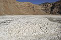
Soda in the inner caldera of Emi Koussi


See also
supporting documents
- ↑ Hellmich 1972, p. 10
- ↑ a b Emi Koussi in the Global Volcanism Program of the Smithsonian Institution (English)
- ^ Gourgaud and Vincent, 2004. p. 261
- ↑ Malin 1977. p. 908
- ↑ Pachur and Altmann 2006. p. 88
- ↑ Malin 1977. p. 908
- ↑ Permenter and Oppenheimer 2007. p. 609
- ↑ RF Peel: The Tibu Peoples and the Libyan Desert . In: The Geographical Journal . 100, No. 2, 1942, p. 75. doi : 10.2307 / 1789494 .
- ↑ Pachur and Altmann 2006. p. 103
- ↑ Pachur and Altmann 2006. p. 88
- ↑ Gèze et al. 1959, p. 137
- ↑ Messerli and Winiger 1992. p. 327
- ^ Gourgaud and Vincent, 2004. p. 264
- ^ Gourgaud and Vincent, 2004. p. 264
- ↑ Tilho 1920. p. 172
- ^ Gourgaud and Vincent, 2004. p. 264
- ↑ Hellmich 1972. p. 21
- ^ Gourgaud and Vincent, 2004. p. 263
- ^ Gourgaud and Vincent, 2004. p. 264
- ^ Gourgaud and Vincent, 2004. p. 263
- ↑ Gourgaud and Vincent, 2004. p. 267
- ↑ a b M. Zimmermann: Chronique Géographique . In: Annales de Géographie . 28, No. 155, 1919, p. 398.
- ↑ Hellmich 1972. p. 172
- ^ Gourgaud and Vincent, 2004. p. 263
- ↑ Gourgaud and Vincent, 2004. p. 267
- ↑ Tilho 1920. p. 172
- ↑ Gèze et al. 1959, p. 137
- ↑ Gourgaud and Vincent, 2004. p. 267
- ↑ Malin 1977. p. 909
- ↑ Pachur and Altmann 2006. p. 103
- ↑ Hellmich 1972. p. 172
- ↑ Gourgaud and Vincent, 2004. p. 267
- ↑ Gèze et al. 1959, p. 139
- ^ Gourgaud and Vincent, 2004. p. 263
- ↑ Permenter and Oppenheimer 2007. p. 621
- ^ Gourgaud and Vincent, 2004. p. 263
- ↑ Poli 1974. p. 225
- ^ Gourgaud and Vincent, 2004. p. 263
- ↑ Permenter and Oppenheimer 2007. p. 616
- ↑ Gèze et al. 1959, p. 137
- ↑ Malin 1977. p. 908
- ↑ International Chronostratigraphic Chart . International Commission on Stratigraphy. August 2018. Retrieved December 4, 2018.
- ^ Gourgaud and Vincent, 2004. p. 264
- ↑ Gourgaud and Vincent, 2004. p. 288
- ↑ Deniel et al. 2015. p. 3
- ↑ Permenter and Oppenheimer 2007. p. 616
- ↑ Deniel et al. 2015. p. 3
- ↑ Malin 1977. p. 908
- ^ Gourgaud and Vincent, 2004. p. 264
- ↑ Permenter and Oppenheimer 2007. p. 616
- ↑ Gèze et al. 1959. p. 138
- ^ Gourgaud and Vincent, 2004. p. 264
- ^ Gourgaud and Vincent, 2004, pp. 268–269
- ↑ Gourgaud and Vincent, 2004. p. 288
- ^ Andrew Smith: Saharo-Sudanese Neolithic . In: Encyclopedia of Prehistory . Springer, Boston, MA, 2001, ISBN 9781468471281 , p. 245, doi : 10.1007 / 978-1-4615-1193-9_19 .
- ↑ Pachur and Altmann 2006. p. 159
- ↑ Pachur and Altmann 2006. p. 119
- ↑ a b Philip Hoelzmann: Crater palaeolakes in the Tibesti mountains (Central Sahara, North Chad) - New insights into past Saharan climates . EGU2016. January 1, 2016.
- ↑ Hellmich 1972. p. 56
- ↑ Pachur and Altmann 2006. p. 119
- ↑ Hellmich 1972. p. 21
- ↑ Tilho 1920. p. 171
- ↑ Dumont 1987. p. 135
- ↑ Dumont 1987. p. 141
- ^ Gourgaud and Vincent, 2004. p. 266
- ^ Gourgaud and Vincent, 2004. p. 268
- ↑ Hellmich 1972. p. 21
- ↑ Bruneau de Miré and Quézel 1959. p. 135
- ↑ Deniel et al. 2015. p. 17
- ^ Gourgaud and Vincent, 2004. p. 264
- ↑ Deniel et al. 2015. p. 18
- ↑ Malin 1977. p. 909
- ^ Gourgaud and Vincent, 2004. p. 264
- ↑ Gourgaud and Vincent, 2004. p. 267
- ^ Gourgaud and Vincent, 2004. p. 264
- ↑ Deniel et al. 2015. p. 8
- ↑ Gourgaud and Vincent, 2004. p. 267
- ^ Gourgaud and Vincent, 2004. p. 264
- ↑ Gourgaud and Vincent, 2004. p. 267
- ↑ Hellmich 1972. p. 22
- ^ Gourgaud and Vincent, 2004. p. 263
- ↑ Gourgaud and Vincent, 2004. p. 267
- ^ C. Oppenheimer: Surveillance and Mapping of Volcanoes and their Emissions by Satellite Remote Sensing . In: Geography . 82, No. 4, 1997, p. 326.
- ↑ Hellmich 1972. p. 22
- ↑ Malin 1977. p. 908
- ↑ Permenter and Oppenheimer 2007. p. 619
- ↑ Gèze et al. 1959, p. 165
- ↑ Malin 1977. p. 908
- ↑ Gèze et al. 1959, p. 139
- ↑ Dumont 1987. p. 134
- ↑ Permenter and Oppenheimer 2007. p. 619
- ↑ Pachur and Altmann 2006. p. 103
- ↑ a b c High mountain research: Tibesti - Central Sahara, work from the high mountain region . In: Universitätsverlag Wagner (Hrsg.): Journal for Glacier Science and Glacial Geology . 8, 1972.
- ↑ Dumont 1987. p. 135
- ↑ Messerli 1973. p. 146
- ↑ Messerli and Winiger 1992. p. 327
- ↑ Messerli 1973. p. 141
- ↑ Dumont 1987. p. 134
- ↑ Messerli and Winiger 1992. p. 317
- ↑ Pachur and Altmann 2006. p. 137
- ↑ Pachur and Altmann 2006. p. 120
- ↑ Lézine et al. 2011. p. 1353
- ↑ Messerli 1973. p. 142
- ↑ Lézine et al. 2011. p. 1354
- ^ A b A. Romo, A. Boratyński: La sección Atlanticae del género Luzula (Juncaceae) . In: Collectanea Botanica . 30, 30 December 2011, ISSN 1989-1067 , p. 55. doi : 10.3989 / collectbot.2011.v30.005 .
- ↑ Poli 1974. p. 226
- ↑ Hellmich 1972. p. 22
- ↑ Hellmich 1972. p. 172
- ↑ Poli 1974. p. 225
- ↑ Bruneau de Miré and Quézel 1959. p. 136
- ↑ Poli 1974. p. 226
- ↑ R. Schnell: Réflexion sur les flores africaines . In: Bulletin de la Société Botanique de France. Actualités Botaniques . 136, No. 3–4, July 10, 2014, p. 116. doi : 10.1080 / 01811789.1989.10826963 .
- ↑ Viane 1987. p. 143
- ↑ Viane 1987. p. 147
swell
- Ph. Bruneau de Miré, P. Quézel: Sur quelques aspects de la Flore residuelle du Tibesti: Les fumeroles du Tousside et les Lappiaz volcaniques cuiminaux de l'Emi Koussi . In: Bulletin de la Société d'histoire naturelle de l'Afrique du Nord . 50, 1959.
- C. Deniel, PM Vincent, A. Beauvilain, A. Gourgaud: The Cenozoic volcanic province of Tibesti (Sahara of Chad): major units, chronology, and structural features . In: Bulletin of Volcanology . 77, No. 9, September 1, 2015, ISSN 0258-8900 , p. 74. bibcode : 2015BVol ... 77 ... 74D . doi : 10.1007 / s00445-015-0955-6 .
- HJ Dumont: African wetlands and shallow water bodies: region 2: Sahara . ORSTOM. Pp. 79-154. 1987. Retrieved April 14, 2018.
- B. Gèze, H. Hudeley, P. Vincent, Ph Wacrenier: Les volcans du Tibesti (Sahara du Tchad) . In: Bulletin Volcanologique . 22, No. 1, December 1, 1959, ISSN 0366-483X , pp. 135-172. bibcode : 1959BVol ... 22..135G . doi : 10.1007 / BF02596582 .
- A Gourgaud, PM Vincent: Petrology of two continental alkaline intraplate series at Emi Koussi volcano, Tibesti, Chad . In: Journal of Volcanology and Geothermal Research . 129, No. 4, January 2004, ISSN 0377-0273 , pp. 261-290. bibcode : 2004JVGR..129..261G . doi : 10.1016 / S0377-0273 (03) 00277-4 .
- Walter Hellmich: High mountain research: Tibesti-Zentrale Sahara work from the high mountain region . University publishing house Wagner, 1972.
- AT THE. Lézine, W. Zheng, P. Braconnot, G. Krinner: Late Holocene plant and climate evolution at Lake Yoa, northern Chad: pollen data and climate simulations . In: Clim. Past . 7, No. 4, December 9, 2011, ISSN 1814-9332 , pp. 1351-1362. bibcode : 2011CliPa ... 7.1351L . doi : 10.5194 / cp-7-1351-2011 .
- MC Malin: Comparison of volcanic features of Elysium (Mars) and Tibesti (Earth) . In: GSA Bulletin . 88, No. 7, July 1, 1977, ISSN 0016-7606 , p. 908. doi : 10.1130 / 0016-7606 (1977) 88 <908: COVFOE> 2.0.CO; 2 .
- B. Messerli: Problems of Vertical and Horizontal Arrangement in the High Mountains of the Extreme Arid Zone (Central Sahara) . In: Arctic and Alpine Research . 5, No. 3, 1973.
- B. Messerli, M. Winiger: Climate, Environmental Change, and Resources of the African Mountains from the Mediterranean to the Equator . In: Mountain Research and Development . 12, No. 4, 1992, pp. 315-336. doi : 10.2307 / 3673683 .
- HJ. Pachur, N- Altmann: The Eastern Sahara in the late Quarter . SpringerLink, 2006, ISBN 978-3-540-47625-2 , doi : 10.1007 / 978-3-540-47625-2 .
- JL Permenter, C. Oppenheimer: Volcanoes of the Tibesti massif (Chad, northern Africa) . In: Bulletin of Volcanology . 69, No. 6, April 1, 2007, ISSN 0258-8900 , pp. 609-626. bibcode : 2007BVol ... 69..609P . doi : 10.1007 / s00445-006-0098-x .
- E. Poli: Facts and Problems of Boundaries in Vegetation (= report on the International Symposium of the International Association for Vegetation Science in Rinteln, April 8-11, 1968). Springer, Dordrecht, 1974, ISBN 9789401175968 , pp. 223-251, doi : 10.1007 / 978-94-011-7595-1_21 .
- J. Tilho: The Exploration of Tibesti, Erdi, Borkou, and Ennedi in 1912-1917: A Mission Entrusted to the Author by the French Institute (Continued) . In: The Geographical Journal . 56, No. 3, 1920, pp. 161-183. doi : 10.2307 / 1781532 .
- RLL Viane: Notes about Asplenium I. Asplenium quezeli, a pseudo-endemic species identical with A. daghestanicum (Aspleniaceae: Pteridophyta) . In: The Fern Gazette . 13, No. 3, 1987. Retrieved April 13, 2018.
Web links
- Original entry was from the NASA Earth Observatory ; [1]
- NASA Earth Explorer page
- A. Gourgaud, PM Vincent: Petrology of two continental alkaline intraplate series at Emi Koussi volcano, Tibesti, Chad . In: Journal of Volcanology and Geothermal Research . 129, No. 4, 2004, pp. 261-290. bibcode : 2004JVGR..129..261G . doi : 10.1016 / S0377-0273 (03) 00277-4 .
- "Emi Koussi" . Peakware.com.
- "Emi Koussi, Chad" on Peakbagger