Wellington Range
| Wellington Range | ||
|---|---|---|
|
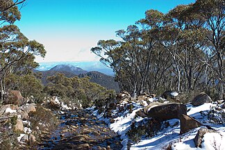
Tom Thumb from Mount Wellington |
||
| Highest peak | Mount Wellington ( 1271 m ) | |
| location | Tasmania | |
|
|
||
| Coordinates | 42 ° 53 ' S , 147 ° 13' E | |
| rock | Diabase | |
The Wellington Range is a mountain range in the southeast of the Australian state of Tasmania . It consists mainly of diabase and shows evidence of earlier glaciation. The most important peaks are Mount Wellington , Collins Cap, Collins Bonnet at Myrtle Forest , Trestle Mountain, Mount Marian, Mount Charles and Mount Patrick at Middle Hill . The Wellington Range is part of the Wellington Park Reserve , a state reserve.
Flora and fauna
The Wellington Range is home to over 500 typical plant species, although most of it is already an alpine region. The mountain range is part of the South-East Tasmanian Important Bird Area , which was declared by BirdLife International because the area is important for the conservation of a number of forest birds, such as B. the endangered swallow parakeet and the Tasman panther bird ( Pardalotus quadragintus ) is.
Individual evidence
- ^ IBA: South-east Tasmania . In: Birdata . Birds Australia. Retrieved October 13, 2011.

