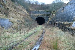
Whitrope tunnel
| Whitrope tunnel | ||
|---|---|---|
|
South portal
|
||
| Official name | Whitrope tunnel | |
| use | Railway tunnel | |
| traffic connection | Waverley Line | |
| place | Scottish Borders , Scotland | |
| length | 1014 meters | |
| Number of tubes | 1 | |
| construction | ||
| Client | North British Railway | |
| business | ||
| release | July 1, 1862 | |
| closure | January 6, 1969 | |
| location | ||
|
|
||
| Coordinates | ||
| North portal | 55 ° 18 ′ 25 ″ N , 2 ° 45 ′ 15 ″ W. | |
| South portal | 55 ° 17 ′ 53 " N , 2 ° 44 ′ 49" W. | |
The Whitrope Tunnel is a former rail tunnel in the Scottish Council Area Scottish Borders . It is located in a sparsely populated region between the towns of Hawick in the north and Newcastleton in the south. In 2003 the structure was included in the Scottish List of Monuments in Monument Category B.
The tunnel, completed around 1860, led the last section of the Waverley Line ( Edinburgh - Carlisle ) opened by the North British Railway in 1862 . It is not far from the highest point of the entire route. It is the fourth longest tunnel in Scotland. The monument protection also includes the Whitrope Viaduct, 700 m to the south, which led the railway line over a country road.
The 1014 meter long tunnel is located on the slopes of Whitrope Summit between Shankend Station and Riccarton Junction Station . It consists of a lined tube with a gradient of just over 1%.
history
Building the tunnel in one of the most remote areas of the line was one of the most demanding tasks in building the Waverley Line. The 230 line workers worked in shifts and were housed near the construction site in temporary housing specially built for this purpose. Two workers died as part of their work. They are buried near the south portal. The Whitrope Viaduct is also called the Golden Bridge . This name goes back to its location near an inn, where the workers mainly enjoyed alcohol.
In addition to the extreme temperatures, the lack of water retention of the sandy bottom caused difficulties during construction. During the construction phase, up to 1900 liters of water per minute entered the tunnel. Therefore, a drainage system was set up, which channeled the water into a drain below the tunnel. Ventilation systems also had to be installed to supply the workers with fresh air. Other problems arose with the construction of the south portal. The unstable rock at the exit point made complex edging necessary. In addition, a stream that flowed at this point had to be diverted. It now runs parallel to the route and is led directly on the other side of the Whitrope Viaduct through a passage that was set up as part of the bridge construction.
The tunnel was opened when the line was opened in 1862 and became obsolete when the line was closed in 1969. As with most parts of the route, the tracks were dismantled. The Waverley Route Heritage Association began setting up a museum between the south portal and the viaduct in the 2000s. There was previously a non-public train station called Whitrope Siding . Over the years, a section of track was rebuilt that extends to the south portal. A restart of the tunnel as part of the museum's operation is being examined.
Whitrope Viaduct
The stone arch bridge spans the B6399 with a segment arch . The road is not orthogonal to the railway line, which results in a diagonal offset. The arch is lined with four layers of brick . A simple metal railing delimits the railway line. On the east side, the stream runs under the railway line. It runs through a lined round arched tube .
Individual evidence
- ↑ a b c d e Listed Building - Entry . In: Historic Scotland .
- ↑ a b c Entry on Whitrope Tunnel in Canmore, the database of Historic Environment Scotland (English)
- ↑ Information from the Waverley Route Heritage Association
Web links
- Entry on Whitrope Tunnel in Canmore, Historic Environment Scotland database


