Newcastleton
| Newcastleton | ||
|---|---|---|
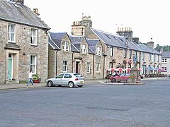
| Douglas Square in the town center | ||
| Coordinates | 55 ° 11 ′ N , 2 ° 49 ′ W | |
|
|
||
| Residents | 768 2011 census | |
| administration | ||
| Post town | NEWCASTLETON | |
| ZIP code section | TD9 | |
| prefix | 01387 | |
| Part of the country | Scotland | |
| Council area | Scottish Borders | |
| British Parliament | Berwickshire, Roxburgh and Selkirk | |
| Scottish Parliament | Ettrick, Roxburgh and Berwickshire | |
Newcastleton , also Copshaw Holm , is a village in the Scottish Council Area Scottish Borders and the traditional county of Roxburghshire . It is located around 32 kilometers south of Hawick and east of Lockerbie on the right bank of Liddel Water . The English- Scottish border runs five kilometers south.
history
The area of today's Newcastleton was historically located in the Scottish-English border area and was therefore the scene of numerous armed conflicts. Hermitage Castle , Goldielands Tower and Branxholme Castle , owned by the Dukes of Buccleuch , are in the vicinity .
Newcastleton was founded in 1793 as a planned settlement by Henry Scott, 3rd Duke of Buccleuch . The duke set up weaving mills there. A primary school established in the 19th century offered space for around 300 pupils. Various markets, especially cattle markets, were held annually on fixed dates.
The 1861 census counted 1124 people in Newcastleton. By 1881 the population had decreased by 200 to 924. A further decrease was recorded in the second half of the 20th century. In 1961, Newcastleton had 927 residents. By 2011 the number had decreased to 768.
traffic
The village is located on the B6357. This follows the course of the Liddel Water and crosses the A7 at Canonbie . In the course of the establishment of the Waverley Line ( Edinburgh - Carlisle ), Newcastleton received its own station in 1862, but this was closed when the Waverley Line was closed in 1969.
Individual evidence
- ↑ a b Entry in the Gazetteer for Scotland
- ^ A b Castleton , in FH Groome: Ordnance Gazetteer of Scotland: A Survey of Scottish Topography, Statistical, Biographical and Historical , Grange Publishing, Edinburgh, 1882-1885.
- ^ Information in the Gazetteer for Scotland
- ↑ 2011 census

