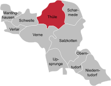
Thüle's residence
The living space of Thüle is an archaeological find place near the lip in North Rhine-Westphalia . It is located 4 km north of Salzkotten in the Paderborn district . At the eastern end of the village, Anton Doms discovered settlement pits from the Roman Empire in 1975 in the trench of a gas pipeline .
Involvement
Thüle's place of residence is 3.5 km south of the Roman camp Anreppen , the easternmost Roman camp on the Lippe, discovered in 1967 and covering around 23 hectares. Anreppen was a hub in the logistics of the Roman army, as the storage capacities for provisions show. Rome led from 16 BC Until the renunciation of Germania magna by Tiberius in Germania under Germanicus reprisals. In order to clarify how Thüle was affected by this, excavations were carried out.
Excavation history
The Westphalian Museum of Archeology carried out an initial investigation in 1995/96, as there was still no evidence of the extent of the ground monument . The plot to the west of the original site provided evidence of a Germanic settlement from the 1st century AD. This dating suggested shards of vessels, but above all two bronze fibulae . Further findings were two pit houses, two storage buildings, some post and several waste pits.
The settlement is built over further to the west. In the north, the destruction of the findings has not been proven, but it is likely.
Further traces of settlement and the ditch of a leveled burial mound from the Middle Bronze Age were found south of the examined parcel . The edge of the settlement was not reached during this excavation.
A strip remained to the east of the first excavation area, which was last examined in several campaigns. There, however, the density of findings decreased noticeably. Instead, some cremation graves from the Bronze and Iron Ages , shard carpets from the Neolithic funnel cup culture as well as flint tools and tees emerged. Most recently, an only slightly sunk pit hut was discovered.
The Germanic settlement
The excavation of the Germanic settlement of Thüle provided post holes (no clear house floor plans), sunk pit huts, garbage pits, iron slag, the lower part of a clay oven (probably for iron smelting), fragments of millstones , spindle whorls and loom weights . The pottery and the other small finds did not show any temporal overlap with the Roman occupation phase. The area must have been undeveloped at the time of the Varus Battle . Traces of devastation by the Roman military are therefore not to be expected in Thüle.
Paleolithic
When setting up the mine hut, the Teutons must have cut into a much older layer of finds. When emptying, numerous flint fragments were found mixed with the finds from the imperial era. The partial area was then tackled using a different excavation technique in order to determine the number of storeys in the finds. This made it possible to get an idea of the Paleolithic conditions.
A thin veil of stone artifacts was initially found in the area adjoining the imperial mine hut. It condensed to an oval concentration of finds 6 × 2 m in size and 0.3 m in thickness. The devices and waste products that the Stone Age hunters left behind in Thüle were small. There are 35 scratches among the approximately 2,000 lithic finds, none of which are longer than 3 cm. The back knives and back tips, which mainly reinforced arrow shafts, were just as small. At Thüle there are the remains of a stone age strike site that was located on a dune that had long been leveled. About 12,000 years ago, hunters had their camp in the slipstream of this dune. There they made devices from flint (flint from glacier deposits).
literature
- D. Berenger: Stone Age Hunters and Germanic Peoples in Thüle In: Archeology in Ostwestfalen Volume 7 Bielefeld 2002, pp. 9-13, ISSN 1434-3398 .
- D. Berenger: Workplace from the Stone Age . In: Archeology in Germany 2002, Issue 4, pp. 49–50, ISSN 0176-8522 .
- R. Reichmann: Teutons in Thüle . In: D. Grothmann (ed.), 750 years city of Salzkotten, history of a Westphalian city. Studies and sources on Westphalian history 32. Paderborn (1996), pp. 563-565.
Coordinates: 51 ° 42 ′ 23.2 " N , 8 ° 36 ′ 24.2" E
