Wrigley (Northwest Territories)
| Wrigley | ||
|---|---|---|
| Location in Canada | ||
|
|
||
| State : |
|
|
| Territory : | Northwest Territories | |
| Region: | Dehcho region | |
| Coordinates : | 63 ° 14 ′ N , 123 ° 28 ′ W | |
| Area : | 55.84 km² | |
| Residents : | 119 (as of 2016) | |
| Population density : | 2.1 inhabitants / km² | |
| Time zone : | Mountain Time ( UTC − 7 ) | |
| Postal code : | X0E 1E0 | |
| Area code : | +1 867 | |
| Mayor : | Maurice Moses | |
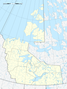
Wrigley is a town with 119 inhabitants (2016 Canadian census) in the Dehcho Region of the Northwest Territories , Canada . It is located on the east bank of the Mackenzies , near the mouth of the Wrigley, 853 km north of Yellowknife and 1,679 km from Edmonton . The place is connected to the surrounding area via the Mackenzie Highway and its own airfield. The airfield ( IATA airport code : YWY, ICAO code : CYWY, Transport Canada Identifier: -) is located southeast of the municipality and has only a 1,066 meter long gravel runway. Wrigley is about 150 feet above sea level.
The majority of the inhabitants of the place belong to the First Nations . They are represented by the Pehdzeh Ki First Nation , which in turn is part of the Dehcho First Nations organization . The residents continue to lead a traditional life: trapping, hunting, fishing. However, there are hotels in Wrigley.
The community was initially based in Fort Wrigley, but moved in 1965 due to better accessibility.
Web links
- Wrigley Northwest Territories Canada ... - Official website of the resort
Individual evidence
- ^ Wrigley Community Profile. Census 2016. In: Statistics Canada . August 9, 2019, accessed September 16, 2019 .
- ↑ Airport diagram. (PDF; 76.5 MB) In: NAV CANADA . Retrieved September 15, 2019 .
