Zagrilla
| Municipality of Priego de Córdoba: Zagrilla | ||
|---|---|---|
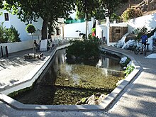
 Street in Zagrilla Alta
|
||
| coat of arms | Map of Spain | |
 Help on coat of arms |
|
|
| Basic data | ||
| Autonomous Community : | Andalusia | |
| Province : | Cordoba | |
| Coordinates | 37 ° 29 ′ N , 4 ° 15 ′ W | |
| Height : | 580 msnm | |
| Residents : | 501 (2011) INE | |
| Postal code : | 14800 | |
| Area code: | 14055002900 | |
| administration | ||
| Website : | www.zagrilla.es | |
Zagrilla is a village in the Spanish province of Cordoba in southern Andalusia . It belongs to the city of Priego de Cordoba and is located about 6 km northwest from the edge of the UNESCO acknowledged Geopark Sierras Subbéticas, the Parque Natural de las Sierras Subbéticas .
Zagrilla had a total of 501 residents in 2011, who are spread over two districts, namely Zagrilla Alta (Oberdorf) and Zagrilla Baja (Unterdorf).
The local economy is largely shaped by agriculture and tourism. In agriculture, olive cultivation is leading and almost every inhabitant of the village is involved in some form. The region's olive oil has two Protected Designations of Origin: Baena and Priego de Córdoba . Sheep and goat cheese are also among the specialties of the area. In tourism, among other things, guided hikes through the nature park are offered.
Individual evidence
- ↑ a b Hiking in the Sierras Subbéticas Nature Park
- ^ Instituto Nacional de Estadistica - INE

