
Karl colliery
| Karl colliery | |||
|---|---|---|---|
| General information about the mine | |||
 |
|||
| Information about the mining company | |||
| Start of operation | 1856 | ||
| End of operation | 1896 | ||
| Funded raw materials | |||
| Degradation of | Eisenstein, Galmei | ||
| Geographical location | |||
| Coordinates | 51 ° 16'25 " N , 7 ° 15'1" E | ||
|
|||
| Location | Langerfeld | ||
| local community | Wuppertal | ||
| Independent city ( NUTS3 ) | Wuppertal | ||
| country | State of North Rhine-Westphalia | ||
| Country | Germany | ||

The Karl Zeche (occasionally also called Zeche Carl ) was an iron and calamine mine in the Langerfeld district of Wuppertal . Today the colliery is a desert without any above-ground buildings, only the underground shafts , tunnels and dies have been preserved. The mine is protected as a ground monument.
location
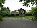
The Karl Zeche was at the western end of today's Galmeistraße near the Langerfeld indoor swimming pool. In brick construction built production well is, according to surveys 48.3 meters deep, will, according to documents but a depth reach of 59 meters. After a restoration of the shaft in 1991, it was provided with a concrete collar into which a glass plate was inserted.
history
Calamine mining in Langerfeld has been known since the middle of the 18th century. In 1835, Friedrich Harkort tried to find a courage for the Karl colliery, which took place in 1856. The colliery mainly mined brown iron stone until it was closed in 1896 .
Redevelopment
In 1990 the city of Wuppertal began to draw up and implement an extensive rehabilitation plan, as the soil in the near-surface area was heavily contaminated by the deposition and relocation of heavy metal-containing overburden. The range of pollutants essentially comprised heavy metals and arsenic with maximum exposure to zinc (up to 110,000 mg / kg), cadmium (up to 180 mg / kg), lead (up to 10,000 mg / kg) and arsenic (up to 330 mg / kg). Since there are now residential areas with a small proportion of commercial and allotment gardens , renovation was inevitable. The renovation of the former Karl colliery included 21 plots in the Schwelmer-, Thuringian-, Ehrenberger-, Eisen- and Gibichostraße as well as the Beyeröhde area. The entire redeveloped area comprises around 6,400 m². A total of 7,625 tons of excavated material was disposed of.
Photo gallery
Karl colliery

The restored shaft end


Individual evidence
- ↑ http://www.aav-nrw.de/Service/broschueren/altlastensanierung_in_nrw.pdf (link not available)
Web links
- Entry in the Wuppertal soil monument list
- Table 17 of the Langerfeld memorial plaques PDF file