
Carpenter's Cross near Ungelstetten

The carpenter's cross is a historic stone cross in the municipality-free area of Winkelhaid in the central Franconian district of Nürnberger Land in Bavaria . It is also called the Croatian Cross or Pandur Cross .
location
The stone cross is located about 1.5 kilometers southwest of Ungelstetten and 1.9 kilometers northeast of Moosbach . It's about 30 meters away and north of a forest road in the forest. The forest road is part of the Gottfried-Stammler-Weg ( ![]() ) and Reichswaldweg (
) and Reichswaldweg ( ![]() ) hiking trails . The administration of the Bavarian State Forests put up an information board on site in 2017.
) hiking trails . The administration of the Bavarian State Forests put up an information board on site in 2017.
description
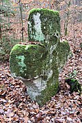
The massive atonement cross is made of sandstone and worked out in the shape of a Greek cross . It is about 130 cm high, 140 cm wide and 35 cm deep. The arms are supported by segments of a circle. According to its size, a third is in the ground. Chisels can be seen on the front and back. Due to weathering, these can no longer be clearly interpreted. Wittmann speaks of a circle and characters on the northern side and a St. Andrew's cross on the opposite side. On the front there is a recess about 5 cm in diameter and 3 cm deep.
History and legend
Its time of origin could be the end of the 15th century. There are various legends about the origin of the cross , but they do not match the presumable date of origin.
- Carpenter's Cross , according to oral tradition, a carpenter was killed here on March 3, 1605.
- Croatian Cross or Pandur Cross , a Croat whose skeleton was seen for years in the library of the University of Altdorf, sitting on a horse's skeleton , is said to have been slain.
- A manslaughter of a Weiherknecht that happened on the same street in 1551.
See also
In the vicinity is the small layer spring Kalter Brunnen and the land monument Rote Marter .
Picture gallery

View of the location from the north (May 2018)

Rear view from the south (May 2018)
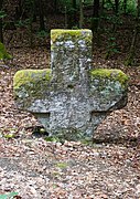
Front view from north (May 2018)
Perspective (Nov. 2012)


Individual evidence
- ↑ BayernAtlas, location of the stone cross (accessed on May 18, 2018)
- ↑ Monuments in the Nuremberg Reichswald ( Bavarian State Forests ), accessed on October 18, 2018, from baysf.de
- ^ Wittmann, Leonhard - Flurdenkmale des Stadt- und Landkreis Nürnberg , in: Das Steinkreuz , 19th year 1963
- ↑ Hühnermann, W. - Stone crosses and pillars of torture in the vicinity of Nuremberg, in: Deutsche Gaue, Vol. 12, 1911, p. 216 under Birnthon
Web links
Coordinates: 49 ° 24 '22.43 " N , 11 ° 16' 53.04" O