Cyclone Catarina
| Category 2 cyclone ( SSHWS ) | ||
|---|---|---|
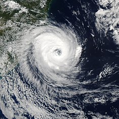
| Catarina on the coast of Brazil at its highest intensity | ||
| Emergence | March 24, 2004 | |
| resolution | March 28, 2004 | |
|
Peak wind speed |
|
|
| Lowest air pressure | 972 hPa ( mbar ) | |
| dead | 3-10 direct | |
| Property damage | US $ 350 million (2004) | |
|
Affected areas |
Santa Catarina and Rio Grande do Sul , Brazil | |
| Season overview: - |
||
The Cyclone Catarina was a tropical cyclone in the South Atlantic and hit the south-eastern Brazil in March 2004. Although he was not the first tropical cyclone in the South Atlantic, he was the first hurricane strength has reached. The storm killed at least three people and caused $ 350 million (today's value: $ 473 million) in damage.
The storm was initially nameless as there was no official naming scheme for the South Atlantic due to the rarity of tropical cyclones in this area . Very soon he was told by local media after the concerned State of Santa Catarina with Catarina named.
Emergence
In general, the South Atlantic south of the equator is considered to be free of tropical hurricane lows, because the cold Benguela Current off the West African coast cools the South Atlantic basin over a large area, and the high water temperature as a basis is therefore missing. It also suppresses the Easterly Waves , undulating winds that are the triggering impulses. Turbulent high-altitude winds in space blow up cells that are formed before they can develop into a rotating storm system. Therefore, the formation of the hurricane was quite surprising.
Storm course
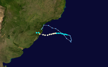
On March 12, a stationary trough formed off the coast of southern Brazil . A disturbance formed on it and moved east-south-east until March 22, when a high pressure wedge located southeast of the system stopped it. Due to unusually good high-altitude winds and above-average warm water temperatures between 24 and 26 ° C, the system was able to develop slowly, and on March 24th resembled a subtropical storm. Located about 1010 km east-southeast of Florianópolis , it was slowly moving west and appeared to have become a tropical storm on March 25th.
As a compact storm, it moved steadily westward and intensified into a hurricane on March 26th . A Brazilian newspaper wrote that a furacao (hurricane) threatened the Brazilian state of Santa Catarina . This headline was one of the reasons for the name Catarina. Catarina continued to receive excellent conditions and reached its greatest intensity with winds of 160 km / h with gusts of up to 180 km / h on March 28th. The cyclone landed on the same day with the same intensity and hit the city of Torres in the state of Rio Grande do Sul, with a population of around 30,000 . Catarina, like a normal tropical cyclone , quickly dissolved over land.
literature
- Ron McTaggart-Cowen, Lance F. Bosart, Christopher A. Davis, Eyad H. Atallah, John R. Gyakum, and Kerry A. Emanuel: Analysis of Hurricane Catarina (2004). In: Monthly Weather Review. Volume 134, November 2006, pp. 3029–3053 (PDF)
Web links
Individual evidence
- ↑ Ron McTaggart-Cowan, Lance F. Bosart, Christopher A. Davis, Eyad H. Atallah, John R. Gyakum and Kerry A. Emanuel: Analysis of Hurricane Catarina (2004) . In: Monthly Weather Review . 134, No. 11, November 2006, pp. 3029-3053. doi : 10.1175 / MWR3330.1 .
- ↑ Tropical storms in Europe too? Mediterranean offers a subtropical climate. wetteronline: Focus on weather topics, undated (accessed September 9, 2015).


