
Bollingstedt
| coat of arms | Germany map | |
|---|---|---|

|
Coordinates: 54 ° 36 ' N , 9 ° 25' E |
|
| Basic data | ||
| State : | Schleswig-Holstein | |
| Circle : | Schleswig-Flensburg | |
| Office : | Arensharde | |
| Height : | 17 m above sea level NHN | |
| Area : | 27.05 km 2 | |
| Residents: | 1408 (Dec. 31, 2019) | |
| Population density : | 52 inhabitants per km 2 | |
| Postal code : | 24855 | |
| Area code : | 04625 | |
| License plate : | SL | |
| Community key : | 01 0 59 010 | |
| LOCODE : | DE 32B | |
| Office administration address: | Hauptstrasse 41 24887 Silberstedt |
|
| Website : | ||
| Mayor : | Marc Praetorius (AWG) | |
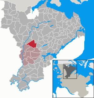
| Location of the municipality of Bollingstedt in the Schleswig-Flensburg district | ||
  |
||

Bollingstedt ( Danish : Bolingsted ) is a municipality in the Schleswig-Flensburg district in Schleswig-Holstein .
geography
The southern Schleswig community of Bollingstedt is located in a wooded part of the Schleswig Geest . The community is characterized by the Bollingsteder Au, the Bollingsteder Moor and the mill pond. The district of Gammellund is located on Lake Gammellund.
Beekholt (Danish Bøgholt ), Bollingstedt-Lund, Engbrück ( Engbro ), Gammellund, Görrisau ( Køså ), Süderfeld and Westerschau ( Vesterskov ) are in the municipality.
history
Bollingstedt was first mentioned in 1196, Gammellund in 1352. The place name Bollingstedt means home of the agglomeration .
During maintenance work between 1975 and 1976 at the Bollingstedter mill pond, old wooden piles were found. One is today 2019 on the north bank of the mill pond in connection with a metal bench. This post is tested for the harvest year 1316 and is probably a section of a tower hill castle which sank in the water after the damming of the mill pond in the 15th century.
Bollingstedt has been awarded thirteen times since 1961 in the competition Our village should be more beautiful , Gammellund ten times. When Bollingstedt became national winner in 1963, Federal President Heinrich Lübke visited the site as part of the competition.
Incorporations
On August 1, 1976, the neighboring municipality of Gammellund was incorporated.
politics
Community representation
Of the 15 seats in the municipal council has Wählergemeinschaft AWG since the municipal election in 2013 seven seats, the voter community KWB five and the SSW two seats.
coat of arms
Blazon : “Lowered divided by gold and blue. At the top three upright green oak leaves side by side, the middle one with two acorns, at the bottom at the division an eight-spoke silver mill wheel below. "
Of particular importance for the place since was medieval water mill on the Bollingstedter Au with the expanded mill pond, probably as part of a castle should be considered. The half mill wheel in the coat of arms of Bollingstedt refers both to the mill itself and to its first verifiable owner. It also characterizes the municipality of Bollingstedt in that the most recent expansion of the town north of the mill pond has taken place. The acorns and oak leaves refer to the district of Gammellund. The part of the name “gammel” means “old” and “lund” in Danish for “ forest , grove ”. Gammellund thus describes an "old forest", and this is the oak forest that still exists in the municipality today.
traffic
The Neumünster – Flensburg railway line and the A 7 run through the municipality . On the stretch between the Bollingstedt and Tarp there is a makeshift motorway airport that has been partially dismantled. It was run by NATO as the “Bollingstedt Highway Strip” during the Cold War , although it is mostly in the neighboring community of Sieverstedt . The emergency landing site served to secure the following and now closed Eggebek air base .
The community can be reached in the north via the Tarp (4) junction of the A 7 and in the south-east via the former B 76 , which has been downgraded to the L 317 , which in Schuby offers a connection to the A 7 to the south and the B 201 to the west.
economy
More and more businesses settled in the originally agricultural community. However, of the original three restaurants in the municipality, only the Gasthof Gammellund has survived.
Attractions
Personalities
The last Catholic bishop of Schleswig Gottschalk von Ahlefeldt (1475–1541) died on Gut Bollingstedt. The professional soccer player Jan-Ingwer Callsen-Bracker (* 1984) played at TSV Bollingstedt in his youth.
Web links
Individual evidence
- ↑ North Statistics Office - Population of the municipalities in Schleswig-Holstein 4th quarter 2019 (XLSX file) (update based on the 2011 census) ( help on this ).
- ^ Federal Statistical Office (ed.): Historical municipality directory for the Federal Republic of Germany. Name, border and key number changes in municipalities, counties and administrative districts from May 27, 1970 to December 31, 1982 . W. Kohlhammer GmbH, Stuttgart / Mainz 1983, ISBN 3-17-003263-1 , p. 185 .
- ↑ Allocation of seats after local elections in 2013
- ↑ Schleswig-Holstein's municipal coat of arms
Ahneby | Alt Bennebek | Arnis | Ausacker | Bergenhusen | Böel | Böklund | Bollingstedt | Bores | Borgwedel | Börm | Böxlund | Brodersby-Goltoft | Busdorf | Dannewerk | Dollerup | Dbodstedt | Eggebek | Ellingstedt | Invent | Esgrus | Fahrdorf | Free will | Gelting | Geltorf | Glücksburg (Baltic Sea) | Grödersby | Great Rheide | Großewiehe | Large voltage | Grundhof | Handewitt | Harrislee | Hasselberg | Havetoft | Hollingstedt | Holt | Hörup | Hürup | Husby | Hüsby | Idstedt | Jagel | Janneby | Jardelund | Jerrishoe | Jörl | Jübek | Kappeln | Folded wood | Klein Bennebek | Klein Rheide | Kronsgaard | Kropp | Long-crowned | Langstedt | Lindewitt | Loit | Lottorf | Lürschau | Maasbüll | Maasholm | Medelby | Meggerdorf | Meyn | Middle fishing | Mohrkirch | Munkbrarup | Neuberend | Nieby | Sneeze gray | Norderbrarup | Nordhackstedt | Nottfeld | Nübel | Oersberg | Oeversee | Osterby | Pommerby | Rabel | Raven wood | Rabenkirchen-Faulück | Ringsberg | Rügge | Saustrup | Schaalby | Schafflund | Scheggerott | Schleswig | Schnarup-Thumby | Schuby | Selk | Sieverstedt | Silberstedt | Sollerup | Soerup | Hatchback | Stack | Steinberg | Steinberg Church | Steinfeld | Sterup | Proud | Stoltebüll | Struxdorf | Süderbrarup | Süderfahrenstedt | Süderhackstedt | Taarstedt | Tarp | Tastrup | Tetenhusen | Tielen | Tolk | Treia | Twedt | Uelsby | Ulsnis | Wagersrott | Wallsbull | Wanderup | Wees | Weesby | Westerholz | Wohlde